Summary
This Rajasthan Government Hub supports Manipur citizens and their democracy by bringing together information, experts, organizations, policy makers, and the public to facilitate greater engagement in federal, state, and local politics and more civil, positive discussions and collaborations on important issues and governance.
This Rajasthan Government Hub is one of many state government hubs being launched next year by the nonpartisan, nonprofit onAir Networks. Other state hubs will be discoverable in the future at the national India Government Hub.
Rajasthan is a state in Northern India.[13][14][15] It covers 342,239 square kilometres (132,139 sq mi) or 10.4 per cent of India’s total geographical area. It is the largest Indian state by area and the seventh largest by population. It is on India’s northwestern side, where it comprises most of the wide and inhospitable Thar Desert (also known as the Great Indian Desert) and shares a border with the Pakistani provinces of Punjab to the northwest and Sindh to the west, along the Sutlej-Indus River valley. It is bordered by five other Indian states: Punjab to the north; Haryana and Uttar Pradesh to the northeast; Madhya Pradesh to the southeast; and Gujarat to the southwest. Its geographical location is 23°3′ to 30°12′ North latitude and 69°30′ to 78°17′ East longitude, with the Tropic of Cancer passing through its southernmost tip.
Source: Wikipedia
OnAir Post: Rajasthan Government Hub
News
Firstpost – July 13, 2023 (05:34)
EU Parliament Debates Manipur Violence, India Calls It “Internal Matter” India rejected the European Parliament’s debate on the violence in Manipur, calling it an issue “totally internal” to India.
The EU debate, that took place ahead of PM Modi’s France visit, seeks to condemn the violence and direct the EU’s top officials to speak to New Delhi about remedying the situation. At least 142 have been killed and more than 54,000 driven from their homes since violence erupted on May 3 this year.
About
Web Links
More Information
Wikipedia

![]()
Rajasthan (Hindi: Rājasthāna, pronounced [ɾaːd͡ʒəsˈtʰaːn] ⓘ; lit. ‘Land of Kings’)[12] is a state in northwestern India.[13][14][15] It is the largest Indian state by area and the seventh largest by population. It covers 342,239 square kilometres (132,139 mi2) or 10.4 per cent of India’s total geographical area. It is on India’s northwestern side, where it comprises most of the wide and inhospitable Thar Desert (also known as the Great Indian Desert) and shares a border with the Pakistani provinces of Punjab to the northwest and Sindh to the west, along the Sutlej–Indus River valley. It is bordered by five other Indian states: Punjab to the north; Haryana and Uttar Pradesh to the northeast; Madhya Pradesh to the southeast; and Gujarat to the southwest. Its geographical location is 23°3′ to 30°12′ North latitude and 69°30′ to 78°17′ East longitude, with the Tropic of Cancer passing through its southernmost tip.
Its major features include the ruins of the Indus Valley civilisation at Kalibangan and Balathal, the Dilwara Temples, a Jain pilgrimage site at Rajasthan’s only hill station, Mount Abu, in the ancient Aravalli mountain range and eastern Rajasthan, the Keoladeo National Park of Bharatpur, a World Heritage Site[16] known for its bird life. Rajasthan is also home to five national tiger reserves, the Ranthambore National Park in Sawai Madhopur, Sariska Tiger Reserve in Alwar, the Mukundra Hills Tiger Reserve in Kota, Ramgarh Vishdhari Tiger reserve and Karauli Dholpur tiger reserve.
The State of Rajasthan was formed on 30 March 1949 when the states of the Rajputana Agency of the erstwhile British Empire in India were merged into the new Indian Union. Its capital and largest city is Jaipur. Other important cities are Jodhpur, Kota, Bikaner, Ajmer, Bhilwara, Sawai Madhopur, Bharatpur and Udaipur. The economy of Rajasthan is the seventh-largest state economy in India with ₹10.20 lakh crore (US$120 billion) in gross domestic product and a per capita GDP of ₹118,000 (US$1,400).[17] Rajasthan ranks 22nd among Indian states in human development index.[18]
Etymology
Rajasthan means “Land of Kings” and is a portmanteau of Sanskrit “Rājā” (‘King’) and Sanskrit “Sthāna” (‘Land’) or Persian “Stān“, with the same meaning.[12] The first printed mention of the name Rajasthan appears in the 1829 publication Annals and Antiquities of Rajasthan or the Central and Western Rajpoot States of India, while the earliest known record of Rajputana as a name for the region is in George Thomas‘s 1800 memoir Military Memories.[19] John Keay, in his book India: A History, stated that Rajputana was coined by the British in 1829, John Briggs, translating Ferishta‘s history of early Islamic India, used the phrase “Rajpoot (Rajput) princes” rather than “Indian princes”.[20]
History
Ancient times
Parts of what is now Rajasthan were partly part of the Vedic Civilisation and the Indus Valley civilisation. Kalibangan, in Hanumangarh district, was a major provincial capital of the Indus Valley Civilisation.[21] Topsfield[22] writes that the Rajputs first entered India from the north west in the first millennium A.D. They established kingdoms in western India in the region that is now known as Rajasthan.[22]
An archaeological excavation at the Balathal site in Udaipur district shows a settlement contemporary with the Harrapan civilisation dating back to 3000–1500 BCE. Stone Age tools dating from 5,000 to 200,000 years were found in Bundi and Bhilwara districts of the state.[23]

The Matsya kingdom of the Vedic civilisation of India is said to roughly correspond to the former state of Jaipur in Rajasthan and included the whole of Alwar with portions of Bharatpur.[25][26] The capital of Matsya was at Viratanagar (modern Bairat), which is said to have been named after its founder King Virata.[27][need quotation to verify]
Bhargava[28] identifies the two districts of Jhunjhunu and Sikar and parts of Jaipur district along with Haryana districts of Mahendragarh and Rewari as part of Vedic state of Brahmavarta. Bhargava also locates the present day Sahibi River as the Vedic Drishadwati River, which along with Saraswati River formed the borders of the Vedic state of Brahmavarta.[29] Manu and Bhrigu narrated the Manusmriti to a congregation of seers in this area. The ashrams of Vedic seers Bhrigu and his son Chayvan Rishi, for whom Chyawanprash was formulated, were near Dhosi Hill, part of which lies in Dhosi village of Jhunjhunu district of Rajasthan and part of which lies in Mahendragarh district of Haryana.[30]
The Western Kshatrapas (405–35 BCE), the Saka rulers of the western part of India, were successors to the Indo-Scythians and were contemporaneous with the Kushans, who ruled the northern part of the Indian subcontinent. The Indo-Scythians invaded the area of Ujjain and established the Saka era (with their calendar), marking the beginning of the long-lived Saka Western Satraps state.[31]
The Allahabad Pillar Inscription (also known as the Prayaga Pillar Inscription) of Samudragupta, AD 360, records that the Abhiras were a powerful tribe who ruled over the whole of Rajasthan.[32]
Classical era
Gurjara-Pratihara

The Pratiharas ruled for many dynasties in this part of the country; the region was known as Gurjaratra.[33] Up to the 10th century, almost all of North India acknowledged the supremacy of the Imperial Pratiharas, with their seat of power at Kannauj.[34]
The Gurjara Pratihar Empire acted as a barrier for Arab invaders from the 8th to the 11th century. The chief accomplishment of the Gurjara-Pratihara Empire lies in its successful resistance to foreign invasions from the west, starting in the days of Junaid. Historian R. C. Majumdar says that this was openly acknowledged by the Arab writers. He further notes that historians of India have wondered at the slow progress of Muslim invaders in India, as compared with their rapid advance in other parts of the world. Now there seems little doubt that it was the power of the Pratihara army that effectively barred the progress of the Arabs beyond the confines of Sindh, their only conquest for nearly 300 years.[35]
Medieval and early modern eras


1525
Rajputana territory (brown), and main South Asian polities c. 1525, on the eve of the establishment of the Mughal Empire.[36][37]
The Ghurids had made an attempt to invade India through southern Rajasthan, however they were defeated in the Battle of Kasahrada on 1178 by a confederacy of Rajputs under Mularaja II of the Kingdom of Gujarat.[38] Prithviraj Chauhan led a confederacy of Rajput clans and defeated the invading Ghruids under Muhammad Ghori in the First Battle of Tarain in 1191. In 1192, Muhammad Ghori decisively defeated Prithviraj at the Second Battle of Tarain. After the defeat of Chauhan in the same year, a part of Rajasthan came under Muslim rulers. The principal centres of their powers were Nagaur and Ajmer. Ranthambhore was also under their suzerainty. At the beginning of the 13th century, the most prominent and powerful state of Rajasthan was Mewar. Since the invasion of the Muslim Turks from the 13th century onwards, the Rajputs resisted the Muslim incursions into India, and preserved Hindu culture at their courts.[22]
The Rajputs put up resistance to the Islamic invasions with their warfare and chivalry for centuries. The Ranas of Mewar led other kingdoms in their resistance to outside rule. Rana Hammir Singh defeated the Tughlaq dynasty and recovered a large portion of Rajasthan. The indomitable Rana Kumbha defeated the Sultans of Malwa, Nagaur and Gujarat and made Mewar the most powerful Rajput Kingdom in India. The ambitious Rana Sanga united the various Rajput clans, including the Muslim Khanzadas of Mewat under Raja Hasan Khan Mewati, and fought against the foreign powers in India. Rana Sanga defeated the Afghan Lodi Empire of Delhi and crushed the Turkic Sultanates of Malwa and Gujarat. Rana Sanga then tried to create an Indian empire but was defeated by the first Mughal Emperor Babur at Khanwa. The defeat was due to betrayal by the Tomar King Silhadi of Raisen. After Rana Sanga‘s death, Marwar rose as a power centre in Rajasthan under Rao Maldeo Rathore. He conquered Jaisalmer, parts of Gujarat, Jalore, Nagaur, Ajmer, Sanchore, Bhinmal, Radhanpur, Bayana, Tonk, Toda and Nabhara. He expanded the territories of Marwar up to Sindh-Cholistan in west and his northern boundary was just fifty kilometres from Delhi.[39][40] After defeating Humayun, Sher Shah came towards Rajputana. He defeated Chiefs of Rathore army by trickery in Battle of Sammel and captured some territory of Marwar but it was recovered by Rathores in 1545.[41]
Hem Chandra Vikramaditya, the Hindu emperor,[42][43] was born in the village of Machheri in Alwar District in 1501. He won 22 battles against Afghans, from Punjab to Bengal including the states of Ajmer and Alwar in Rajasthan, and defeated Akbar’s forces twice, first at Agra and then at Delhi in 1556 at Battle of Delhi[44] before acceding to the throne of Delhi and establishing the “Hindu Raj” in North India, albeit for a short duration, from Purana Qila in Delhi. Hem Chandra was killed in the battlefield at Second Battle of Panipat fighting against Mughals on 5 November 1556.

During Akbar‘s reign most of the Rajput kings accepted Mughal suzerainty, but the rulers of Mewar (Rana Udai Singh II) and Marwar (Rao Chandrasen Rathore) refused to have any form of alliance with the Mughals. To teach the Rajputs a lesson Akbar attacked Udai Singh and killed Rajput commander Jaimal of Chitor and the citizens of Mewar in large numbers. Akbar killed 20,000–25,000 unarmed citizens in Chittor on the grounds that they had actively helped in the resistance.[45]
Maharana Pratap took an oath to avenge the citizens of Chittor; he fought the Mughal empire till his death and liberated most of Mewar apart from Chittor itself. Maharana Pratap soon became the most celebrated warrior of Rajasthan and became famous all over India for his sporadic warfare and noble actions. According to Satish Chandra, “Rana Pratap’s defiance of the mighty Mughal empire, almost alone and unaided by the other Rajput states, constitutes a glorious saga of Rajput valor and the spirit of self-sacrifice for cherished principles. Rana Pratap’s methods of sporadic warfare were later elaborated further by Malik Ambar, the Deccani general, and by Shivaji”.[46]
Rana Amar Singh I continued his ancestor’s war against the Mughals under Jehangir, he repelled the Mughal armies at Dewar. Later an expedition was again sent under the leadership of Prince Khurram, which caused much damage to life and property of Mewar. Many temples were destroyed, several villages were put on fire and women and children were captured and tortured to make Amar Singh accept surrender.[47]
During Aurangzeb‘s rule Rana Raj Singh I, Veer Durgadas Rathore and Patshah Akheraj Singh Rajpurohit[48][49] were chief among those who defied the intolerant emperor of Delhi. They took advantage of the Aravalli hills and caused heavy damage to the Mughal armies that were trying to occupy Rajasthan.[50][51]
After Aurangzeb’s death Bahadur Shah I tried to subjugate Rajasthan like his ancestors but his plan backfired when the three Rajput Rajas of Amber, Udaipur, and Jodhpur made a joint resistance to the Mughals. The Rajputs first expelled the commandants of Jodhpur and Bayana and recovered Amer by a night attack. They next killed Sayyid Hussain Khan Barha, the commandant of Mewat and many other Mughal officers. Bahadur Shah I, then in the Deccan was forced to patch up a truce with the Rajput Rajas.[52] The Jats, under Suraj Mal, overran the Mughal garrison at Agra and plundered the city taking with them the two great silver doors of the entrance of the famous Taj Mahal which were then melted down by Suraj Mal in 1763.[53]
Over the years, the Mughals began to have internal disputes which greatly distracted them at times. The Mughal Empire continued to weaken, and with the decline of the Mughal Empire in the late 18th century, Rajputana came under the influence of the Marathas. The Maratha Empire, which had replaced the Mughal Empire as the overlord of the subcontinent, was finally replaced by the British Empire in 1818.[54]
In the 19th century, the Rajput kingdoms were exhausted financially and in manpower after continuous wars and due to heavy tributes exacted by the Maratha Empire. To save their kingdoms from instability, rebellions and banditry the Rajput kings concluded treaties with the British in the early 19th century, accepting British suzerainty and control over their external affairs in return for internal autonomy.[55]
![Rana Kumbha was the vanguard of the fifteenth century Rajput resurgence.[56]](https://upload.wikimedia.org/wikipedia/commons/thumb/d/d1/Maharana_Kumbhakarna_of_Mewar.jpg/250px-Maharana_Kumbhakarna_of_Mewar.jpg) Rana Kumbha was the vanguard of the fifteenth century Rajput resurgence.[56]
Rana Kumbha was the vanguard of the fifteenth century Rajput resurgence.[56] The emperor Hemu, who rose from obscurity and briefly established himself as ruler in northern India, from Punjab to Bengal, in defiance of the warring Sur and Mughal Empires.
 Durgadas Rathore, a Rathore Rajput warrior of Jodhpur who played an important role in protecting the Rathore dynasty of Marwar and for his rebellion against Aurangzeb.
 Maharana Pratap Singh, sixteenth-century Rajput ruler of Mewar, known for his defence of his realm against Mughal invasion.
![Suraj Mal was ruler of Bharatpur. Some contemporary historians described him as "the Plato of the Jat people" and by a modern writer as the "Jat Odysseus", because of his political sagacity, steady intellect and clear vision.[57]](https://upload.wikimedia.org/wikipedia/commons/thumb/4/4d/Maharaja_Suraj_Mal.jpg/250px-Maharaja_Suraj_Mal.jpg)
![Rana Kumbha was the vanguard of the fifteenth century Rajput resurgence.[56]](https://en.wikipedia.org/wiki/File:Maharana_Kumbhakarna_of_Mewar.jpg)


![Suraj Mal was ruler of Bharatpur. Some contemporary historians described him as "the Plato of the Jat people" and by a modern writer as the "Jat Odysseus", because of his political sagacity, steady intellect and clear vision.[57]](https://en.wikipedia.org/wiki/File:Maharaja_Suraj_Mal.jpg)
Modern era
The State of Rajasthan was formed on 30 March 1949 when the states of the Rajputana Agency[58] of the erstwhile British Empire in India were merged into the new Indian Union. Modern Rajasthan includes most of Rajputana, which comprises the erstwhile nineteen princely states, three chiefships, and the British district of Ajmer-Merwara.[59] Jaisalmer, Marwar (Jodhpur), Bikaner, Mewar (Chittorgarh), Alwar and Dhundhar (Jaipur) were some of the main Rajput princely states. Bharatpur and Dholpur were Jat princely states whereas Tonk was a princely state under Pathans. The three chiefships were Lawa, Neemrana and Kushalgarh.[60]
Geography
The geographic features of Rajasthan are the Thar Desert and the Aravalli Range, which runs through the state from southwest to northeast, almost from one end to the other, for more than 850 kilometres (530 mi).[61] Mount Abu lies at the southwestern end of the range, separated from the main ranges by the West Banas River.[62] Although a series of broken ridges continues into Haryana in the direction of Delhi where it can be seen as outcrops in the form of the Raisina Hill and the ridges farther north. About three-fifths of Rajasthan lies northwest of the Aravallis, leaving two-fifths on the east and south direction.

The Aravalli Range runs across the state from the southwest peak Guru Shikhar (Mount Abu), which is 1,722 metres (5,650 ft) in height, to Khetri in the northeast.[63] This range divides the state into 60% in the northwest of the range and 40% in the southeast. The northwest tract is sandy and unproductive with little water but improves gradually from desert land in the far west and northwest to comparatively fertile and habitable land towards the east. The south-eastern area, higher in elevation (100 to 350 m above sea level) and more fertile, has a very diversified topography. In the south lies the hilly tract of Mewar. In the southeast, a large area within the districts of Kota and Bundi forms a tableland.[63] To the northeast of these districts is a rugged region (badlands) following the line of the Chambal River. Farther north the country levels out; the flat plains of the northeastern Bharatpur district are part of an alluvial basin. Merta City lies in the geographical centre of Rajasthan.[63]
The Aravalli Range and the lands to the east and southeast of the range are generally more fertile and better watered. This region is home to the Khathiar-Gir dry deciduous forests ecoregion, with tropical dry broadleaf forests that include teak, Acacia, and other trees. The hilly Vagad region, home to the cities of Dungarpur, Pratapgarh, and Banswara lies in southernmost Rajasthan, on the border with Gujarat and Madhya Pradesh. With the exception of Mount Abu, Vagad is the wettest region in Rajasthan, and the most heavily forested. North of Vagad lies the Mewar region, home to the cities of Udaipur and Chittaurgarh. The Hadoti region lies to the southeast, on the border with Madhya Pradesh. North of Hadoti and Mewar lies the Dhundhar region, home to the state capital of Jaipur. Mewat, the easternmost region of Rajasthan, borders Haryana and Uttar Pradesh. Eastern and southeastern Rajasthan is drained by the Banas and Chambal rivers, tributaries of the Ganges.
The northwestern portion of Rajasthan is generally sandy and dry. Most of this region is covered by the Thar Desert which extends into adjoining portions of Pakistan. The Aravalli Range does not intercept the moisture-giving southwest monsoon winds off the Arabian Sea, as it lies in a direction parallel to that of the coming monsoon winds, leaving the northwestern region in a rain shadow. The Thar Desert is thinly populated; the City of Jodhpur is the largest city in the desert and a major metropolitan area of India which is known as the gateway of the Thar desert. The desert has some major districts like Jodhpur, Jaisalmer, Barmer, Bikaner, and Nagaur. This area is also important from a defence point of view. Jodhpur airbase is one of the largest airbases in India, BSF and Military bases are also situated here. Currently four civil airports are located here: Jodhpur, Jaisalmer, Bikaner and Nagaur, of which Jodhpur is the major civil airport, being the 44th busiest airport in India and one of the oldest air strips of India, being built in the 1920s.
The Northwestern thorn scrub forests lie in a band around the Thar Desert, between the desert and the Aravallis. This region receives less than 400 mm of rain annually. Temperatures can sometimes exceed 45 °C in the summer months and drop below freezing point in the winter. The Godwar, Marwar, and Shekhawati regions lie in the thorn scrub forest zone, along with the city of Jodhpur. The Luni River and its tributaries are the major river system of Godwar and Marwar regions, draining the western slopes of the Aravallis and emptying southwest into the great Rann of Kutch wetland in neighbouring Gujarat. This river is saline in the lower reaches and remains potable only up to Balotara in Barmer district. The Ghaggar River, which originates in Haryana, is an intermittent stream that disappears into the sands of the Thar Desert in the northern corner of the state and is seen as a remnant of the primitive Sarasvati river.
 Mount Abu is a popular hill station in Rajasthan.
 The Thar Desert near Jaisalmer.
 Aerial view Udaipur and Aravali hills.


Flora and fauna
| Formation day | 1 November |
| State animal | Chinkara[64] and camel[65] |
| State bird | Godavan (great Indian bustard)[64] |
| State flower | Rohida[64] |
| State tree | Khejadi |

The Desert National Park in Jaisalmer, spread over an area of 3,162 square kilometres (1,221 sq mi), is an excellent example of the ecosystem of the Thar Desert and its diverse fauna.[66] Seashells and massive fossilised tree trunks in this park record the geological history of the desert. The region is a haven for migratory and resident birds of the desert. One can see many eagles, harriers, falcons, buzzards, kestrels and vultures. Short-toed snake eagles (Circaetus gallicus), tawny eagles (Aquila rapax), spotted eagles (Aquila clanga), laggar falcons (Falco jugger) and kestrels are some of the raptor species seen in Desert National Park. Road traffic inside the Park is, however, a threat to several wild species of the park with several species of amphibians, reptiles, birds and mammals reported to have died as roadkill.[67]
The Ranthambore National Park located in Sawai Madhopur,[68] one of the well known tiger reserves in the country, became a part of Project Tiger in 1973.
Tal Chhapar Sanctuary is a very small sanctuary in Sujangarh, Churu District, 210 kilometres (130 mi) from Jaipur in the Shekhawati region. This sanctuary is home to a large population of blackbuck. Desert foxes and the caracal, an apex predator, also known as the desert lynx, can also be spotted, along with birds such as the partridge, harriers, eastern imperial eagle, pale harrier, marsh harrier, short-toed eagle, tawny eagle, sparrow hawk, crested lark, demoiselle crane, skylarks, green bee-eater, brown dove, black ibis, and sand grouse.[69] The great Indian bustard, known locally as the godavan, and which is a state bird, has been classed as critically endangered since 2011.[70]
Wildlife protection

Rajasthan is also noted for its national parks and wildlife sanctuaries. There are four national parks and wildlife sanctuaries: Keoladeo National Park of Bharatpur, Sariska Tiger Reserve of Alwar, Ranthambore National Park of Sawai Madhopur, and Desert National Park of Jaisalmer. A national-level institute, Arid Forest Research Institute (AFRI) an autonomous institute of the ministry of forestry is situated in Jodhpur and continuously works on desert flora and their conservation.
Ranthambore National Park is 7 km from Sawai Madhopur Railway Station. It is known worldwide for its tiger population and is considered by both wilderness lovers and photographers as one of the best places in India to spot tigers. At one point, due to poaching and negligence, tigers became extinct at Sariska, but five tigers have been relocated there.[71] Prominent among the wildlife sanctuaries are Mount Abu Sanctuary, Bhensrod Garh Sanctuary, Darrah Sanctuary, Jaisamand Sanctuary, Kumbhalgarh Wildlife Sanctuary, Jawahar Sagar Sanctuary, and Sita Mata Wildlife Sanctuary.
Governance and administration

The state is governed by a parliamentary system of representative democracy. The governor serves as the state’s constitutional leader, whereas the chief minister assumes the role of both the head of the government and the head of the council of ministers. The Legislative Assembly consists of 200 members who are elected for five-year terms. The state contributes 25 seats to Lok Sabha, the lower house of the Indian Parliament, and 10 seats to Rajya Sabha, the upper house.[72][73]
The Government of Rajasthan is a democratically elected body in India with the governor as its constitutional head. Governor is appointed by the President of India for a five-year term. The leader of the party or coalition with a majority in the Legislative Assembly is appointed as the chief minister by the governor, and the council of ministers are appointed by the governor on the advice of the chief minister. The governor remains a ceremonial head of the state, while the chief minister and his council are responsible for day-to-day government functions. The council of ministers consists of Cabinet Ministers, Ministers of State (MoS) and Deputy Ministers. The Secretariat headed by the Chief Secretary assists the council of ministers. The Chief Secretary is also the administrative head of the government. Each government department is headed by a minister, who is assisted by an Additional Chief Secretary or a Principal Secretary, who is usually an officer of Indian Administrative Service (IAS), the Additional Chief Secretary/Principal Secretary serve as the administrative head of the department they are assigned to. Each department also has officers of the rank of Secretary, Special Secretary, Joint Secretary etc. assisting the Minister and the Additional Chief Secretary/Principal Secretary.
For the administration purpose, the state is divided into 07 divisions and 41 districts. Divisional Commissioner, is the head of administration on the divisional level.[74] The administration in each district is headed by a District Collector/District Magistrate, who is also an IAS officer, and is assisted by a number of officers belonging to Rajasthan Administrative Services. In Rajasthan, the police force is led by an IPS officer holding the position of Director General of Police. Each district is supervised by a Superintendent of Police, also an IPS officer, who is supported by officers from the Rajasthan Police Services. Their primary responsibility involves maintaining law and order and addressing relevant issues within their respective districts. The management of forests, environment, and wildlife in the district is overseen by the Divisional Forest Officer, who is a member of the Indian Forest Service. This responsibility is carried out with the assistance of officers from the Rajasthan Forest Service and Rajasthan Subordinate Service.

Rajasthan has its High court Jodhpur which has its principal seat at Jodhpur and a bench at Jaipur, with district courts and session courts in each district or Sessions Division, and lower courts at the tehsil level.[75] The president of India appoints the chief justice of the High Court of Rajasthan judiciary on the advice of the Chief Justice of the Supreme Court of India as well as the governor of Rajasthan. In Rajasthan, the Subordinate Judicial Service is an essential component of the state’s judiciary, and it is divided into two categories: the Rajasthan Civil Judicial Services and the Rajasthan Higher Judicial Service.[76] The former includes Civil Judges (Junior Division)/Judicial Magistrates and Civil Judges (Senior Division)/Chief Judicial Magistrate. On the other hand, the latter consists of Civil and Sessions Judges. The District Judge has control over the Subordinate Judicial Service in Rajasthan.
The politics of Rajasthan has mainly been dominated mainly by the Bharatiya Janata Party and the Indian National Congress.
Chief Secretary Of Rajasthan is Usha Sharma[77] and Director General of Police or DGP of Rajasthan is Umesh Mishra.[78]
Regions, divisions, districts and cities


Rajasthan is composed of the following geographical, political and historical regions:
Rajasthan is divided into 41 districts within 7 divisions:
| Division | Districts |
|---|---|
| Ajmer | |
| Bharatpur | |
| Bikaner | |
| Jaipur | |
| Jodhpur | |
| Kota | |
| Udaipur |
A district collector and district magistrate, who is appointed by the government from the cadre of Indian Administrative Service or Rajasthan Administrative Service, administer each district. Each district is divided into subdivisions headed by a Sub-Divisional Magistrate (SDM), comprising tehsils under Tehsildars, primarily responsible for land revenue administration.[79] Additionally, districts are further divided into blocks for rural development administration, headed by Block Development Officers (BDOs). A block consists of panchayats (village councils).
Panchayat Samitis are intermediate level panchayat between the Zilla Parishad (district councils) at the district level and gram panchayat (village councils) at the lower level. These Panchayati Raj institutions govern rural areas of districts, with elections held every five years.[80]
Rajasthan has 5 cities with over one million population. The absolute urban population of the state is 17.4 million, which constitutes 24.87% of the total urban population of the state. There are 10 municipal corporations, 34 municipal councils and 172 municipal boards or nagar parishads in the state. Jaipur, Jodhpur, and Kota have two municipal corporations each since October 2019, as their populations have exceeded 1 million.[81]
Communication
Major internet service provider (ISP) and telecom companies are present in Rajasthan including Vodafone Idea, BSNL, Airtel, Jio, Data Infosys Limited, RailTel Corporation of India, Software Technology Parks of India (STPI). Data Infosys was the first ISP to bring the internet to Rajasthan in April 1999[82] and OASIS was the first private mobile telephone company.
Economy
_develpment_2016_2018_2020.png)
Rajasthan’s economy is primarily agricultural and pastoral. Wheat and barley are cultivated over large areas, as are pulses, sugarcane, and oilseeds. Cotton and tobacco are the state’s cash crops. Rajasthan is among the largest producers of edible oils in India and the second-largest producer of oilseeds. Rajasthan is also the biggest wool-producing state in India and the main opium producer and consumer. There are mainly two crop seasons. The water for irrigation comes from wells and tanks. The Indira Gandhi Canal irrigates northwestern Rajasthan.

The main industries are mineral based, agriculture-based, and textile based. Rajasthan is the second-largest producer of polyester fibre in India. Several prominent chemical and engineering companies are located in the city of Kota, in southern Rajasthan. Rajasthan is pre-eminent in quarrying and mining in India. The Taj Mahal was built from white marble which was mined from a town called Makrana. The state is the second-largest source of cement in India. It has rich salt deposits at Sambhar, copper mines at Khetri, Jhunjhunu, and zinc mines at Dariba, Zawar mines and Rampura Agucha (opencast) near Bhilwara. Dimensional stone mining is also undertaken in Rajasthan. Jodhpur sandstone is mostly used in monuments, important buildings, and residential buildings. This stone is termed as Chittar Patthar. Jodhpur leads in the handicraft and guar gum industries.
Rajasthan is also a part of the Mumbai-Delhi Industrial corridor set to benefit economically. The state gets 39% of the DMIC, with major districts of Jaipur, Alwar, Kota and Bhilwara benefiting.[83]
Rajasthan also has reserves of low-silica limestone.[84]
Rajasthan connected 100% of its population to electricity power in 2019 (raising the rate of electricity access from 71% of the population in 2015).[85] The renewable energy sector plays the most important role in the increase of generation capacities, with the main focus on solar energy. In 2020, Bhadla Solar Park was recognised as the largest cluster of photovoltaic power plants in a single region in the world, with the installed power exceeding the 2.2 gigawatt peak.
Rajasthan is also a significant producer of silver. The state produced 679.172 tonnes of silver in 2018–19, 609.153 tonnes in 2019–20, and 705.676 tonnes in 2020–21.[86]
Transportation
Rajasthan is connected by many national highways, the most renowned being NH 8, which is India’s first 4–8 lane highway.[87] Rajasthan also has an inter-city surface transport system both in terms of railways and bus network. All chief cities are connected by air, rail, and road.
Air
Jaipur International Airport (JAI) in Jaipur, is the state’s largest, busiest and only international airport. Jaipur International Airport offers international service to Dubai, Bangkok, Sharjah and Muscat. There are five civilian airports in Rajasthan including Jodhpur Airport, Udaipur Airport, Ajmer Airport, Bikaner Airport and Jaisalmer Airport.[88] Domestic airports are operated by the Airports Authority of India (AAI) and shares its airside with the Indian Air Force. These airports connect Rajasthan with the major cities of India such as Mumbai, Kolkata, Hyderabad, Chennai and Bangalore.
Railway
Railways length in the state constitute 8.66 per cent of all India route length. Jaipur Junction is the headquarters of the North Western Railway.[89] Jaipur, Ajmer, Bikaner are the busiest railway stations in the state. Kota is the only electrified section served by three Rajdhani Expresses and trains to all major cities of India. Jaipur Superfast Express, fastest train under Superfast category of trains; connects the finance capital of India Mumbai to Jaipur. Luxury tourist train Maharajas’ Express runs across North-West and Central India, mainly centred on Rajasthan. There is also an international railway, the Thar Express from Jodhpur (India) to Karachi (Pakistan). However, this is not open to foreign nationals. Jaipur Metro is the metro rail system in the city of Jaipur. It is the only metro rail system in Rajasthan and has been operational since 3 June 2015. It is the first metro in India to run on triple-storey elevated road and metro track.
Road
The state is served by a substantial road network, providing links between urban centres, agricultural market-places and rural areas. There are 33 national highways (NH) in the state, covering a total distance of 10,004.14 km (6,216.28 mi).[90] The state has a total road length of 269,028 km (167,166 mi). The Department of Public Works is responsible for maintaining and expanding the state highways system and major district roads. Jaipur–Kishangarh Expressway forms a segment of the NH-8 which is a part of the Golden Quadrilateral project. Rajasthan State Road Transport Corporation (RSRTC) was established in 1964 to provide economical and reliable passenger road transport service in the state with connecting services to adjoining states.[91] For travelling locally, the state, like most of the country, has auto rickshaws and cycle rickshaws. Average speed on state highways varies between 50 and 60 kilometres per hour (31–37 mph) due to the heavy presence of vehicles; in villages and towns, speeds are as low as 25–30 km/h (16–19 mph).[92]

 Maharajah’s Express dining saloon
 The Jaipur Metro is an important urban transportation link
_02.jpg)
.jpg)


Demographics
Population
| Year | Pop. | ±% p.a. |
|---|---|---|
| 1901 | 10,294,090 | — |
| 1911 | 10,983,509 | +0.65% |
| 1921 | 10,292,648 | −0.65% |
| 1931 | 11,747,974 | +1.33% |
| 1941 | 13,863,859 | +1.67% |
| 1951 | 15,970,774 | +1.42% |
| 1961 | 20,155,602 | +2.35% |
| 1971 | 25,765,806 | +2.49% |
| 1981 | 34,261,862 | +2.89% |
| 1991 | 44,005,990 | +2.53% |
| 2001 | 56,507,188 | +2.53% |
| 2011 | 68,548,437 | +1.95% |
| source:[93] | ||
According to the 2011 Census of India, Rajasthan has a total population of 68,548,437.[5] The state contributes to 5.66% of India’s population. The population density is 201 people per square kilometre. The sex ratio in 2011, at 928 women to 1000 men, was lower than the national figure of 943. The native Rajasthani people make up the majority of the state’s population. The state of Rajasthan is also populated by Sindhis, who came to Rajasthan from Sindh province (now in Pakistan) during the India-Pakistan separation in 1947.[94]
Brahmins, according to Outlook constituted 8% to 10% of the population of Rajasthan as per a 2003 report, but only 7% in a 2007 report.[95][96] According to a 2007 DNA India report, 12.5% of the state are Brahmins.[97] According to a report by Moneycontrol.com at the time of 2018 Rajasthan Legislative Assembly election, the Scheduled Caste (SC) population was 18%, Scheduled Tribe (ST) was 13%, Jats 12%, Gurjars and Rajputs 9% each, Brahmins and Meenas 7% each.[98] A Hindustan Times report from 2019 also agrees to the total ST population of 13%, of which Meenas constitute the biggest group at 7%.[99] According to a Deutsche Welle report, the Jats constitute 12–15% of the population of Rajasthan, followed by Meenas with 10% and Gurjars with 6%.[100] While as per a 2007 BBC Hindi report, Meenas were 14% and Gurjars were 4% of the state’s population.[101]
| City | Population |
|---|---|
| Jaipur | |
| Jodhpur | |
| Kota | |
| Bikaner | |
| Ajmer | |
| Udaipur | |
| Bhilwara | |
| Alwar | |
| Bharatpur | |
| Sri Ganganagar |
Language
Hindi is the official language of the state, while English is the additional official language.[15]
The languages of Rajasthan primarily belong to the Rajasthani group of Indo-Aryan languages, which most people regard as their own language. In the north are dialects of Punjabi and Bagri, which is a transition between Rajasthani and Punjabi. In the northeast Shekhawati and Dhundari are spoken which gradually merge with Haryanvi. In the east Mewati is spoken in the Mewat region, while in the far east Braj is spoken.[103] To the southeast Haryanvi is spoken. To the west in the heart of the Thar Desert Marwari is spoken, which merges to Gujarati in the southwest. In the south, in the Mewar region, Mewari is spoken, while in the hills of Wagad, Wagdi, a Bhil language, is spoken. Many speakers of Rajasthani languages refer to their language as Hindi, and Standard Hindi is the medium of education and is common in cities. Urdu is also common in cities although the vast majority of Muslims speak one of the Rajasthani languages as their first language. Sindhi is also common in the cities and along the border with Sindh in Pakistan where Dhatki, a transition between Marwari and Sindhi, is the main dialect on both sides of the border.[citation needed] The literacy rate of Rajasthan was 66.11% according to the 2011 census of India.[104]
The languages taught under the three-language formula are:[105]
- First language: Hindi
- Second language: English
- Third language: Gujarati, Punjabi, Sanskrit, Sindhi or Urdu
Religion
Rajasthan’s residents are mainly Hindus, who account for 88.49% of the population. Muslims make up 9.07%, Sikhs 1.27% and Jains 0.91% of the population.
Culture
| Part of a series on |
| Rajasthani people |
|---|
| Culture |
| Religion |
| Language |
| Notable people |
| Rajasthan Portal |
Food

Rajasthani cooking was influenced by both the war-like lifestyles of its inhabitants and the availability of ingredients in this arid region. Food that could last for several days and could be eaten without heating was preferred. Thus, pickles of Rajasthan are quite famous for their tangy and spicy flavour. The Panchkuta delicacy is also a famous one – meaning 5 vegetables – a dish that lasts for several days, and is made out of certain weed plants that only grow in the wild desert. The scarcity of water and fresh green vegetables have all had their effect on cooking. It is known for its snacks like Bikaneri Bhujia.[107] Other famous dishes include bajre ki roti (millet bread) and lahsun ki chutney (hot garlic paste), mawa kachori Mirchi Bada, Pyaaj Kachori and ghevar from Jodhpur, Alwar ka Mawa (milk cake),[108] Kadhi kachori from Ajmer, Malpua from Pushkar, Daal kachori (Kota kachori) from Kota and rassgullas from Bikaner.[citation needed] Originating from the Marwar region of the state is the concept of Marwari Bhojnalaya or vegetarian restaurants, today found in many parts of India, which offer vegetarian food popular among Marwari people. Ghee is an essential ingredient in most Rajasthani cuisines, and dollops of ghee are poured over food as a welcoming gesture for guests.

Dal-baati-churma is very popular in Rajasthan. The traditional way to serve it is to first coarsely mash the baati, and then pour pure ghee on top of it. It is served with daal (lentils) and spicy garlic chutney; it is also served with besan (gram flour) ki kadi. It is commonly served at all festivities, including religious occasions, wedding ceremonies, and birthday parties in Rajasthan.[109]
Music and dance
The Ghoomar dance from Jaipur, Jodhpur, and Kalbelia of the Kalbelia tribe has gained international recognition.[110] Folk music is a large part of the Rajasthani culture. The Manganiyar, Meena and Langa communities from Rajasthan are notable for their folk music. Kathputli, Bhopa, Chang, Teratali, Ghindr, Gair dance, Kachchhi Ghori, and Tejaji are examples of traditional Rajasthani culture.[111] Folk songs are commonly ballads that relate heroic deeds and love stories; and religious or devotional songs known as bhajans and banis which are often accompanied by musical instruments like dholak, sitar, and sarangi are also sung.
Art

Rajasthan is known for its traditional, colourful art. The block prints, tie and dye prints, gota patti (main), Bagaru prints, Sanganer prints, and Zari embroidery are major export products from Rajasthan. Handicraft items like wooden furniture and crafts, carpets, and blue pottery are commonly found here.[112] Shopping reflects the colourful culture, Rajasthani clothes have a lot of mirror work and embroidery. Traditional Rajasthani dress for females consists of an ankle-length skirt and a short top, known as chaniya choli.[113] A piece of cloth is used to cover the head, both for protection from heat and maintenance of modesty. Rajasthani dresses are usually designed in bright colours such as blue, yellow, and orange.
Education

In recent years, Rajasthan has worked on improving education. The state government has been making sustained efforts to raise the education standard.
Schools in the state are either managed by the government or by private trusts. The medium of instruction in most of the schools is mainly English, or Hindi. Under the 10+2+3 plan, after completing secondary school, students typically enroll for two years in a junior college, also known as pre-university, or in schools with a higher secondary facility affiliated with the Board of Secondary Education or any central board. Students choose from one of three streams, namely liberal arts, commerce, or science. Upon completing the required coursework, students may enrol in general or professional degree programs. The secondary schools are affiliated with the Council for the Indian School Certificate Examinations (CISCE), the Central Board for Secondary Education (CBSE), and the National Institute of Open School (NIOS).
Rajasthan has 52 universities, 26 state funded public universities, 7 deemed universities, an IIT in Jodhpur, an IIM in Udaipur, an NIT in Jaipur, a National Law University in Jodhpur, and one central and state-run university.[114][115] Kota, is renowned for being a hub for training students in various national-level competitive exams that are necessary for securing admission to engineering and medical colleges across the country. In order to promote a reading culture among the rural population, the state has established new libraries up to the panchayat level and computerised all public libraries throughout the state, providing modern amenities to readers and subscriber.[116]
Literacy
In recent decades the literacy rate of Rajasthan has increased significantly. In 1991, the state’s literacy rate was only 38.55% (54.99% male and 20.44% female). In 2001, the literacy rate increased to 60.41% (75.70% male and 43.85% female). This was the highest leap in the percentage of literacy recorded in India (the rise in female literacy being 23%).[117] At the Census 2011, Rajasthan had a literacy rate of 67.06% (80.51% male and 52.66% female). Although Rajasthan’s literacy rate is below the national average of 74.04% and although its female literacy rate is the lowest in the country, the state has been praised for its efforts and achievements in raising literacy rates.[118][119]
In rural areas of Rajasthan, the literacy rate is 76.16% for males and 45.8% for females. This has been debated across all the party levels, when the governor of Rajasthan set a minimum educational qualification for the village panchayat elections.[120][121][122]
Tourism

Rajasthan attracted a total of 45.9 million domestic and 1.6 million foreign tourists in 2017, which is the tenth highest in terms of domestic visitors and fifth highest in foreign tourists.[123] The tourism industry in Rajasthan is growing effectively each year and is becoming one of the major income sources for the state government.[124] Rajasthan is home to many attractions for domestic and foreign travellers, including the forts and palaces of Jaipur, the lakes of Udaipur, the temples of Rajsamand and Pali, sand dunes of Jaisalmer and Bikaner, Havelis of Mandawa and Fatehpur, the wildlife of Sawai Madhopur, the scenery of Mount Abu, the tribes of Dungarpur and Banswara, and the cattle fair of Pushkar.
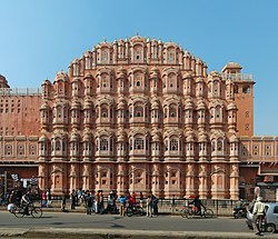
Rajasthan is known for its customs, culture, colours, majestic forts, and palaces, folk dances and music, local festivals, local food, sand dunes, carved temples and Havelis.[citation needed] Rajasthan’s Jaipur Jantar Mantar, Mehrangarh Fort and Stepwell of Jodhpur, Dilwara Temples, Chittor Fort, Lake Palace, miniature paintings in Bundi, and numerous city palaces and Havelis are part of the architectural heritage of India. Jaipur, the Pink City, is noted for the ancient houses made of a type of sandstone dominated by a pink hue. In Jodhpur, most houses are painted blue.[125] At Ajmer, there is white marble Bara-dari on the Anasagar lake and Soniji Ki Nasiyan. Jain Temples dot Rajasthan from north to south and east to west. Dilwara Temples of Mount Abu, Shrinathji Temple of Nathdwara, Ranakpur Jain temple dedicated to Lord Adinath in Pali District, Jain temples in the fort complexes of Chittor, Jaisalmer and Kumbhalgarh, Lodurva Jain temples, Mirpur Jain Temple of Sirohi, Sarun Mata Temple at Kotputli, Bhandasar and Karni Mata Temple of Bikaner and Mandore of Jodhpur are some of the best examples.[126] Keoladeo National Park, Ranthambore National Park, Sariska Tiger Reserve, Tal Chhapar Sanctuary, are wildlife attractions of Rajasthan. Mewar festival of Udaipur, Teej festival and Gangaur festival in Jaipur, Desert festival of Jodhpur, Brij Holi of Bharatpur, Matsya festival of Alwar, Kite festival of Jodhpur, Kolayat fair in Bikaner are some of the most popular fairs and festivals of Rajasthan.
 Camel rides in Thar desert
 Pushkar Lake and Ghat
 Kalbelia, a folk dance popular in Rajasthan
 Amber Fort as seen from the bank of Maotha Lake, Jaigarh Fort on the hills in the background

 Delicate marble carving at Dilwara Temples
 Kirti Stambha of Chittor Fort
 Tiger at Ranthambore National Park


.jpg)


.jpg)

.jpg)

See also
References
- ^ “Ahead of Assembly polls, Gehlot announces formation of 19 new districts in Rajasthan”. The Hindu. 17 March 2023. ISSN 0971-751X. Archived from the original on 17 March 2023. Retrieved 17 March 2023.
- ^ “BJP’s Veteran Haribhau Kisanrao Bagde Named Rajasthan Governor: 5 Points”. NDTV. 28 July 2024. Retrieved 28 July 2024.
- ^ “Physiography of Rajasthan”. Environment Portal. Government of Rajasthan. Archived from the original on 24 March 2023. Retrieved 24 March 2023.
- ^ “Guru Shikhar…Mount Abu”. National Informatics Centre. 10 April 2009. Archived from the original on 10 April 2009. Retrieved 24 March 2023.[better source needed]
- ^ a b “Rajasthan Profile” (PDF). Census of India. Archived (PDF) from the original on 16 September 2016. Retrieved 21 July 2016.
- ^ a b “Report of the Commissioner for linguistic minorities: 52nd report (July 2014 to June 2015)” (PDF). Commissioner for Linguistic Minorities, Ministry of Minority Affairs, Government of India. pp. 34–35. Archived from the original (PDF) on 28 December 2017. Retrieved 16 February 2016.
- ^ “Finance Department, GoR” (PDF). finance.rajasthan.gov.in. Archived from the original on 23 February 2023. Retrieved 23 February 2023.
- ^ “India: Subnational HDI”. Global Data Labs. Retrieved 8 June 2025.
- ^ “Appendix-A: Detailed tables, Table (7): Literacy rate (in per cent) of persons of different age groups for each State/UT (persons, age-group (years): 7 & above, rural+urban (column 6))”. Annual Report, Periodic Labour Force Survey (PLFS) (July 2023 – June 2024) (PDF). National Sample Survey Office, Ministry of Statistics and Programme Implementation, Government of India. 23 September 2024. pp. A-10.
- ^ “Sex ratio of State and Union Territories of India as per National Health survey (2019–2021)”. Ministry of Health and Family Welfare, India. Archived from the original on 8 January 2023. Retrieved 8 January 2023.
- ^ “Symbols of Rajasthan”. Government of Rajasthan. Archived from the original on 14 November 2016. Retrieved 13 November 2016.
- ^ a b Boland-Crewe, Tara; Lea, David (2003). The Territories and States of India. Routledge. p. 208. ISBN 978-1-135-35625-5. Retrieved 26 October 2019.
- ^ “Inter-state Council Secretariat – Ministry of Home Affairs, Government of India”. Ministry of Home Affairs. Archived from the original on 17 February 2017. Retrieved 1 December 2018.
- ^ “North Zone Cultural Centre”. Ministry of Culture, Government of India. Archived from the original on 19 October 2018. Retrieved 1 December 2018.
- ^ a b “Report of the Commissioner for linguistic minorities: 50th report (July 2012 to June 2013)” (PDF). Commissioner for Linguistic Minorities, Ministry of Minority Affairs, Government of India. p. 22. Archived from the original (PDF) on 8 July 2016. Retrieved 26 December 2014.
- ^ “World Heritage List”. Archived from the original on 30 October 2010. Retrieved 18 March 2011.
- ^ “MOSPI Net State Domestic Product, Ministry of Statistics and Programme Implementation, Government of India”. Archived from the original on 23 March 2020. Retrieved 7 April 2020.
- ^ “Sub-national HDI – Area Database”. Global Data Lab. Archived from the original on 23 September 2018. Retrieved 13 September 2018.
- ^ F. K. Kapil (1990). Rajputana states, 1817–1950. Book Treasure. p. 1. Archived from the original on 1 January 2016. Retrieved 15 November 2015.
- ^ John Keay (2001). India: a history. Grove Press. pp. 231–232. ISBN 978-0-8021-3797-5. Archived from the original on 1 January 2016. Retrieved 15 November 2015.
Colonel James Todd, who, as the first British official to visit Rajasthan, spent most of the 1820s exploring its political potential, formed a very different idea of “Rush boots” […] and the whole region thenceforth became, for the British, ‘Rajputana’. The word even achieved a retrospective authenticity, [for,] in [his] 1829 translation of Ferishta’s history of early Islamic India, John Bridge discarded the phrase ‘Indian princes’, as rendered in Dow’s earlier version, and substituted ‘Rajpoot princes’.
- ^ “Indus Valley Civilization Related Articles arsenical bronze writing, literature”. Amazines.com. Archived from the original on 20 December 2011. Retrieved 5 June 2012.
- ^ a b c Jain, Kulbhushan (1998). “Spatial Organisation and Aesthetic Expression in the Traditional Architecture of Rajasthan”. Paradigms of Indian Architecture. Routledge. p. 159. ISBN 978-0-7007-1038-6.
- ^ Pillai, Geetha Sunil (28 February 2017), “Stone age tools dating back 200,000 years found in Rajasthan”, The Times of India, archived from the original on 17 April 2019, retrieved 23 August 2018
- ^ Cunningham, Sir Alexander (1871). Archaeological Survey Of India Four Reports Made During The Years 1862 – 63 – 64 – 65 Volume Ii. pp. 242–248. Archived from the original on 31 October 2023. Retrieved 31 October 2023.
- ^ Chatterjee, Ramanand (1948). The Modern review (History). Vol. 84. Prabasi.
- ^ Sita Sharma; Pragati Prakashan (1987). Krishna Leela theme in Rajasthani miniatures. p. 132.
- ^ Rajasthan aajtak. ISBN 978-81-903622-6-9.
- ^ Sudhir Bhargava. “Location of Brahmavarta and Drishadwati river is important to find earliest alignment of Saraswati river”. Seminar, Saraswati river: a perspective, 20–22 November 2009, Kurukshetra University, Kurukshetra, organized by Saraswati Nadi Shodh Sansthan, Haryana. Seminar report: pages 114–117
- ^ Manusmriti
- ^ Jain, M. S. (1 January 1993). Concise History of Modern Rajasthan. Wishwa Prakashan. ISBN 978-81-7328-010-8.
- ^ John Rosenfield, The dynastic art of the Kushans, p. 130.
- ^ Amr̥tarāya (1991). A house divided : the origin and development of Hindi-Urdu. Internet Archive. Delhi; New York : Oxford University Press. p. 51. ISBN 978-0-19-562811-1.
- ^ Majumdar, R. C., ed. (1994). “Ancient India”. The Age of imperial Kanauj. Motilal Banarsidassr. p. 263. ISBN 978-81-208-0436-4. Retrieved 15 November 2015.
- ^ Asiatic Society of Bombay (1904). Journal of the Asiatic Society of Bombay. Vol. 21. Royal Asiatic Society of Great Britain and Ireland. Bombay Branch. p. 432.
Up to the tenth century almost the whole of North India, excepting Bengal, owned their supremacy at Kannauj.
- ^ Radhey Shyam Chaurasia (2002). History of Ancient India: Earliest Times to 1000 A.D. Atlantic. pp. 207–208. ISBN 978-81-269-0027-5.
- ^ Schwartzberg, Joseph E. (1978). A Historical atlas of South Asia. Chicago: University of Chicago Press. p. 39, 147. ISBN 0226742210.
- ^ “Historical Atlas of India” by Charles Joppen (London: Longmans, Green & Co., 1907)
- ^ Bhatia, P. (1970). The Paramāras: (c. 800 – 1305 A.D.); a Study in the Political and Cultural History of Their Kingdoms. Munshiram Manoharlal. ISBN 978-81-215-0410-2. Retrieved 1 May 2022.
- ^ Rima Hooja, “The State of Marwar/Jodhpur”, in History of Rajasthan, pp. 520–522
- ^ Majumdar, R.C., ed. (2006). The Mughul Empire. Mumbai: Bharatiya Vidya Bhavan. pp. 81–82.
- ^ Mahajan, V. D. (1991, reprint 2007). History of Medieval India, Part II. New Delhi: S. Chand. p. 43.
- ^ Sarkar, Sir Jadunath (1960). Military History of India. Orient Longmans. ISBN 978-0-86125-155-1.
{{cite book}}: ISBN / Date incompatibility (help) - ^ Coetzee, Daniel; Eysturlid, Lee W. (21 October 2013). Philosophers of War: The Evolution of History’s Greatest Military Thinkers. ABC-CLIO. ISBN 978-0-313-07033-4.
- ^ Bhardwaj, K. K. Hemu: Napoleon of Medieval India. New Delhi: Mittal Publications, p. 25
- ^ Richards, John F. (1995). The Mughal Empire. Cambridge University Press. p. 26. ISBN 978-0-521-56603-2.
- ^ Chandra, Satish (2000). Medieval India. New Delhi: National Council of Educational Research and Training. p. 164.
- ^ Pant, Ashok (2012). The Truth of Babri Mosque. iUniverse. p. 129. ISBN 978-1-4759-4289-7.
- ^ Dr Prahalad Singh Rajpurohit,”Veer Kesari Singh Rajpurohit ka Jasprakash”
- ^ Sevaṛa, Prahalādasiṃha (2021). Rājapurohita jāti kā itihāsa (Dvitīya saṃsodhita saṃskaraṇa ed.). Jodhapura. ISBN 978-93-90179-06-0.
{{cite book}}: CS1 maint: location missing publisher (link) - ^ Niccolò Manucci, Storia do Mogor
- ^ Cambridge History of India, p. 304
- ^ The Cambridge History of India, Volume 3, p. 322
- ^ Dwivedi, Girish Chandra; Prasad, Ishwari (1989). The Jats, Their Role in the Mughal Empire. Arnold Publishers. pp. 56–61. ISBN 978-81-7031-150-8.
- ^ Hallissey, Robert C. (1977). The Rajput Rebellion Against Aurangzeb: A Study of the Mughal Empire in Seventeenth-century India. University of Missouri Press. pp. 34–41. ISBN 978-0-8262-0222-2.
- ^ Bhargava, Visheshwar Sarup (1966). Marwar and the Mughal Emperors (A.D. 1526–1748). Munshiram Manoharlal. pp. 123–126. ISBN 978-81-215-0400-3.
- ^ Sen, Sailendra (2013). A Textbook of Medieval Indian History. Primus Books. pp. 116–117. ISBN 978-9-38060-734-4.
- ^ R. C. Majumdar, H. C. Raychaudhury, Kalikaranjan Datta: An Advanced History of India, 4th ed., 1978,ISBN 0-333-90298-X, p. 535
- ^ R.K. Gupta; S.R. Bakshi (1 January 2008). Studies in Indian History: Rajasthan Through The Ages The Heritage Of Rajputs (Set Of 5 Vols.). Sarup & Sons. pp. 143–. ISBN 978-81-7625-841-8. Retrieved 15 November 2015.
- ^ R. K. Gupta; S. R. Bakshi (1 January 2008). Studies in Indian History: Rajasthan Through the Ages the Heritage of Rajputs. Sarup & Sons. pp. 143–. ISBN 978-81-7625-841-8. Retrieved 15 November 2015.
- ^ Lodha, Sanjay (2011). “Subregions, Identity and Nature of Political Competition in Rajasthan”. In Kumar, Ashutosh (ed.). Rethinking State Politics in India: Regions within Regions. Routledge. p. 400. ISBN 978-0-415-59777-7. Retrieved 12 December 2019.
The 19 independent ruling houses were governed by different Rajput clans, Jats and Pathans. The Chauhan Rajputs ruled Bundi, Kota and Sirohi; the Gehlot Rajputs ruled Banswara, Dungarpur, Mewar, Pratapgarh and Shahpura; the Jadon Rajputs ruled Jaisalmer and Karauli; the Jhala Rajputs were the rulers of Jhalawar; the Kachhawaha Rajputs controlled Alwar, Jaipur and the Lawa Estate; and the Rathore Rajputs looked after Bikaner, Marwar, Kishangarh and the chiefship of Kushalgarh. Bharatpur and Dholpur were under Jat rule and Tonk was ruled by the Pathans.
- ^ “Southern Asia: Western India into Pakistan”. WWF. Archived from the original on 12 April 2023. Retrieved 3 August 2023.
- ^ “Geography of Mount Abu”. Mountabu Online. Archived from the original on 3 August 2023. Retrieved 3 August 2023.
- ^ a b c “Topographical divisions”. Rajasthan Foundation. Archived from the original on 3 August 2023. Retrieved 3 August 2023.
- ^ a b c “States and Union Territories Symbols”. Archived from the original on 12 November 2013. Retrieved 7 July 2014.
- ^ “Now the state animal camel”. Patrika Group. 1 July 2014. Archived from the original on 6 August 2014. Retrieved 7 July 2014.
- ^ “Desert National Park”. UNESCO World Heritage Centre. UNESCO. Archived from the original on 16 May 2022. Retrieved 26 June 2009.
- ^ Kumawat, Rakesh; Ashok, Purohit (2020). “Impact and assessment of wildlife mortalities on road due to vehicular movements in Desert National Park, Rajasthan, India” (PDF). Asian Journal of Conservation Biology. 9 (1): 173–177. Archived (PDF) from the original on 1 March 2024. Retrieved 1 March 2024.
- ^ Sadhu, Ayan; Jayam, Peter Prem Chakravarthi; Qureshi, Qamar; Shekhawat, Raghuvir Singh; Sharma, Sudarshan; Jhala, Yadvendradev Vikramsinh (28 November 2017). “Demography of a small, isolated tiger (Panthera tigris tigris) population in a semi-arid region of western India”. BMC Zoology. 2: 16. doi:10.1186/s40850-017-0025-y. ISSN 2056-3132.
- ^ “Tal Chhapar Black Buck Sanctuary”. Inside Indian Jungles. 29 June 2013. Archived from the original on 8 April 2019. Retrieved 5 April 2019.
- ^ BirdLife International (2018). “Ardeotis nigriceps“. IUCN Red List of Threatened Species. 2018 e.T22691932A134188105. doi:10.2305/IUCN.UK.2018-2.RLTS.T22691932A134188105.en. Retrieved 13 November 2021.
- ^ “A tale of two tiger reserves”. The Hindu. Jaipur. 21 March 2012. Archived from the original on 3 February 2014. Retrieved 29 January 2014.
- ^ “MEMBERS OF RAJYA SABHA (STATE WISE LIST)”. Rajya Sabha. Archived from the original on 26 March 2023. Retrieved 26 March 2023.
- ^ “State-wise Representation Of Members”. Lok Sabha. Archived from the original on 26 March 2023. Retrieved 26 March 2023.
- ^ “Civil Officer Details”. Department of Personnel (DOP), Rajasthan. Archived from the original on 26 March 2023. Retrieved 26 March 2023.
- ^ “Judiciary”. Government of Rajasthan. Archived from the original on 26 March 2023. Retrieved 26 March 2023.
- ^ “History Of The Rajasthan High Court”. Rajasthan High Court. Archived from the original on 10 August 2023. Retrieved 3 August 2023.
- ^ “Chief Secretary – Rajasthan Government”. Rajasthan.gov.in. Archived from the original on 20 April 2023. Retrieved 20 April 2023.
- ^ “राजस्थान पुलिस के मुखिया बने उमेश मिश्रा, जानें कौन हैं गहलोत के पसंदीदा IPS अफसर DGP मिश्रा?”. Navbharat Times. Archived from the original on 20 April 2023. Retrieved 20 April 2023.
- ^ “Notifications – Revenue Units”. Government of Rajasthan, India. Retrieved 3 January 2026.
- ^ “State Election Commission, Rajasthan”. Government of Rajasthan. Retrieved 4 January 2025.
- ^ “Rajasthan: Jaipur, Jodhpur and Kota to get additional municipal corporations”. ETGovernment.com. Archived from the original on 26 March 2023. Retrieved 8 October 2020.
- ^ “Rajasthan’s first ISP”. timesofindia-economictimes. Archived from the original on 10 June 2016. Retrieved 10 June 2016.
- ^ “Business Opportunities”. Government of Rajasthan. Archived from the original on 10 February 2014. Retrieved 11 February 2014.
- ^ “Rajasthan state mines and minerals limited”. Archived from the original on 5 June 2018. Retrieved 14 June 2018.
- ^ Naimoli, Stephen; Singh, Kartikeya (October 2019). “Engaging with India’s Electrification Agenda: Powering Rajasthan” (PDF). Center for Strategic and International Studies (CSIS). Archived (PDF) from the original on 16 July 2020. Retrieved 16 July 2020.
- ^ “Indian Minerals Yearbook 2021 – Silver” (PDF). Indian Bureau of Mines (60 ed.). February 2023.
- ^ “Rajasthan National Highways – List of Rajasthan Roads and Highway”. Archived from the original on 14 December 2016. Retrieved 18 December 2016.
- ^ “A comprehensive guide to airports in India”. Indigo. Archived from the original on 28 March 2023. Retrieved 28 March 2023.
- ^ “North Western Railway / Indian Railways Portal”. Indian Railways. Archived from the original on 9 April 2023. Retrieved 9 April 2023.
- ^ “Development of Roads and Highways in Rajasthan”. Ministry of Road Transport & Highways. Archived from the original on 27 March 2023. Retrieved 27 March 2023.
- ^ “rsrtc.gov.in”. Archived from the original on 12 January 2012. Retrieved 18 December 2016.
- ^ “Speed limit on expressways”. HT Auto. Hindustan Times. 7 September 2022. Archived from the original on 9 April 2023. Retrieved 9 April 2023.
- ^ “Census of India Website: Office of the Registrar General & Census Commissioner, India”. www.censusindia.gov.in. Archived from the original on 8 August 2019. Retrieved 13 December 2019.
- ^ “Census of India”. Archived from the original on 13 September 2015. Retrieved 21 September 2015.
- ^ “Distribution Of Brahmin Population”. Outlook. 16 June 2003. Archived from the original on 6 August 2020. Retrieved 7 December 2019.
- ^ “Brahmins in India”. Outlook. 4 June 2007. Archived from the original on 30 July 2019. Retrieved 8 December 2019.
- ^ “Rajasthan’s Brahmins now seek job quotas”. DNA India. 26 June 2007. Archived from the original on 6 December 2019. Retrieved 7 December 2019.
- ^ Handa, Aakriti (25 October 2018). “Rajasthan Assembly Polls 2018: The caste dynamics in the state and the race for reservations”. Moneycontrol. Archived from the original on 27 March 2020. Retrieved 27 March 2020.
- ^ Goswami, Rakesh (7 July 2019). “In Rajasthan, tribal body acts as family court for ST couples”. Hindustan Times. Archived from the original on 6 April 2022. Retrieved 7 April 2022.
- ^ “आखिर क्यों भड़कते हैं आरक्षण के आंदोलन | DW | 12 February 2019”. Deutsche Welle (in Hindi). Archived from the original on 12 May 2022. Retrieved 12 May 2022.
- ^ “वसुंधरा के लिए सांप छछूंदर वाली स्थिति”. BBC (in Hindi). June 2007. Archived from the original on 12 May 2022. Retrieved 12 May 2022.
- ^ “Language – India, States and Union Territories” (PDF). Census of India 2011. Office of the Registrar General. pp. 13–14. Archived (PDF) from the original on 14 November 2018. Retrieved 22 March 2019.
- ^ Yogesh, Kumar, Ritesh Lahiri, Bornini Alok, Deepak Ojha, Atul Kr. Jain, Mayank Basit, Abdul Dawer (26 March 2018). Automatic Identification of Closely-related Indian Languages: Resources and Experiments. OCLC 1228352635.
{{cite book}}: CS1 maint: multiple names: authors list (link) - ^ “Chapter-3 (Literates and Literacy Rate) – Rajasthan” (PDF). Office of the Registrar General and Census Commissioner of India. p. 46. Retrieved 19 November 2025.
- ^ “51st Report of the Commissioner for Linguistic Minorities in India” (PDF). nclm.nic.in. Ministry of Minority Affairs. 15 July 2015. p. 44. Archived from the original (PDF) on 16 February 2018. Retrieved 15 February 2018.
- ^ “Population by religion community – 2011”. Census of India, 2011. The Registrar General & Census Commissioner, India. Archived from the original on 25 August 2015.
- ^ “It’s one of India’s tastiest snacks. But there’s only one place you can sample the real thing”. CNN. 12 September 2022. Archived from the original on 21 April 2023. Retrieved 21 April 2023.
- ^ “In search of Alwar Ka Kalakand”. The Hindu. 6 July 2013. Archived from the original on 21 April 2023. Retrieved 21 April 2023.
- ^ “TBI Food Secrets: The Fascinating History Behind Rajasthan’s Traditional Dish Dal Baati Churma”. The better India. 2 November 2016. Archived from the original on 21 April 2023. Retrieved 21 April 2023.
- ^ “Ghoomar Dance – Folk Dance of Rajasthan”. Rajasthan direct. Archived from the original on 5 December 2022. Retrieved 21 April 2023.
- ^ “Rajasthan: अपनी परंपरा और संस्कृति को दर्शाते हैं राजस्थान के ये 8 लोक नृत्य, देशभर में रखते हैं अलग पहचान”. Abp live. 16 September 2022. Archived from the original on 21 April 2023. Retrieved 21 April 2023.
- ^ “Handicraft in Rajasthan”. Archived from the original on 21 April 2023. Retrieved 21 April 2023.
- ^ “Women’s Traditional Dress”. The culture trip. 26 March 2018. Archived from the original on 21 April 2023. Retrieved 21 April 2023.
- ^ “List of State Funded Universities”. Raj Bhawan, Rajasthan. Archived from the original on 9 April 2023. Retrieved 9 April 2023.
- ^ Saroha, Sakshi (3 February 2023). “Maximum number of universities in Rajasthan, colleges in UP: AISHE Report”. Indian Express. Indian Express Group. Archived from the original on 9 April 2023. Retrieved 9 April 2023.
- ^ “Libraries”. Government of Rajasthan. Archived from the original on 9 April 2023. Retrieved 9 April 2023.
- ^ “Directorate of Literacy and Continuing Education: Government of Rajasthan”. Rajliteracy.org. Archived from the original on 23 March 2012. Retrieved 5 June 2012.
- ^ “Rajasthan literacy rate now 67.06: Census Data | Census 2011 Indian Population”. Census2011.co.in. 27 April 2011. Archived from the original on 23 March 2012. Retrieved 5 June 2012.
- ^ “Rajasthan Population 2011 – Growth rate, literacy, sex ratio in Census 2011 “2011 Updates” InfoPiper”. Infopiper.com. Archived from the original on 23 March 2012. Retrieved 5 June 2012.
- ^ “Rajasthan Governor fixes minimum education qualifications for Panchayat polls”. The Indian Express. 22 December 2014. Archived from the original on 7 July 2015. Retrieved 16 June 2015.
- ^ “Lok Sabha TV Insights: Educational Qualification and Elections”. INSIGHTS. 6 January 2015. Archived from the original on 8 April 2015. Retrieved 16 June 2015.
- ^ “Rajasthan Education”. Rajshiksha. Archived from the original on 5 December 2015. Retrieved 18 September 2015.
- ^ “Tourist Visited in India 2017” (PDF). tourism.gov.in. Archived (PDF) from the original on 27 November 2018. Retrieved 24 November 2018.
- ^ Raina, A. K.; Agarwal, S. K. (2004). The Essence of Tourism Development: Dynamics, Philosophy, and Strategies. Sarup & Sons. p. 264. ISBN 978-81-7625-527-1.
important source of tax revenue and total revenue of the state government of Rajasthan besides the income creation and employment generation
- ^ Forster, Stuart. “Why is Jodhpur Known as the Blue City?”. Times of India. Archived from the original on 31 October 2019. Retrieved 2 November 2019.
- ^ “Tourist Places to Visit in Rajasthan – Rajasthan Tourism”. tourism.rajasthan.gov.in. Archived from the original on 16 November 2016. Retrieved 16 November 2016.
Further reading
- Bhattacharya, Manoshi. 2008. The Royal Rajputs: Strange Tales and Stranger Truths. Rupa & Co, New Delhi.
- Gahlot, Sukhvirsingh. 1992. RAJASTHAN: Historical & Cultural. J. S. Gahlot Research Institute, Jodhpur.
- Somani, Ram Vallabh. 1993. History of Rajasthan. Jain Pustak Mandir, Jaipur.
- Tod, James & Crooke, William. 1829. Annals and Antiquities of Rajasthan or the Central and Western Rajpoot States of India,. Numerous reprints, including 3 Vols. Reprint: Low Price Publications, Delhi. 1990.ISBN 81-85395-68-3 (set of 3 vols.)
- Mathur, P.C., 1995. Social and Economic Dynamics of Rajasthan Politics (Jaipur, Aaalekh)
External links
Government
General information
 Geographic data related to Rajasthan at OpenStreetMap
- The Modern Endangered Archives Program Hereditary Music of Western Rajasthan collection is available through the UCLA Library.
| Outline |  | ||||||||||||||
|---|---|---|---|---|---|---|---|---|---|---|---|---|---|---|---|
| Governance | |||||||||||||||
| Divisions and districts |
| ||||||||||||||
| Major cities | |||||||||||||||
| Related templates | |||||||||||||||
| International | |
|---|---|
| National | |
| Geographic | |
| Academics | |
| Other | |
Wikipedia
Manipur (/ˌmænɪˈpʊər/, IPA: [məɳiˈpʊɾ])[9] is a state in northeastern India with Imphal as its capital. It borders the Indian states of Assam to the west, Mizoram to the south, and Nagaland to the north and shares the international border with Myanmar, specifically the Sagaing Region to the east and Chin State to the southeast. Covering an area of 22,330 square kilometers (8,621 mi²), the state consists mostly of hilly terrain with the 1813-square-kilometre (700 mi²) Imphal Valley inhabited by the Meitei (Manipuri) community, historically a kingdom. Surrounding hills are home to Naga and Kuki-Zo communities, who speak Tibeto-Burman languages.[10][11] The official language and lingua franca, Meitei (Manipuri), also belongs to the Tibeto-Burman family.[12]
During the days of the British Raj, Manipur was one of the princely states.[13] Prior to the British departure in 1947, Manipur acceded to the Dominion of India, along with roughly 550 other princely states.[14] In September 1949, the ruler of Manipur signed a merger agreement with India, giving up his kingdom and obtaining a privy purse in return.[15] Many Meitei people feel that their self-determination was violated by the agreement since the legislature elected under the constitution was not consulted.[16] Ethnic and separatist concerns have resulted in a long-running insurgency against Indian rule.[16] From 2009 through 2018, the conflict was responsible for the violent deaths of over 1000 people.[17]
The Meitei people represent around 53% of the population of Manipur state, followed by various Naga tribes at 20% and Kuki-Zo tribes at 16%.[18] Manipur's ethnic groups practice a variety of religions.[19] According to 2011 census, Hinduism and Christianity are the major religions of the state.[19]
Manipur has primarily an agrarian economy, with significant hydroelectric power generation potential. It is connected to other areas by daily flights through Imphal Airport, the second largest in northeastern India.[20] Manipur is home to many sports and the origin of Manipuri dance,[21] and is credited with introducing polo to Europeans.[22]
Name
The name Manipur (Sanskrit: मणिपुर, romanized: maṇipura, lit. ''city of jewels'') was chosen by Gharib Nawaz in the eighteenth century. It is named after a kingdom of the same name mentioned in the Mahabharata Hindu epic. Previously, it had been known as Kangleipak (Meitei: ꯀꯪꯂꯩꯄꯛ, romanized: Kangleipak)[23][24] or Meiteileipak (Meitei: ꯃꯩꯇꯩꯂꯩꯕꯥꯛ, Meiteileipak, transl: land of the Meiteis).[25] Later, the work Dharani Samhita (1825–34) popularised the Sanskrit legends of the origin of Manipur's name.[26]
Other names include Sanaleibak (Meitei: ꯁꯅꯥꯂꯩꯕꯥꯛ, transl: the land of gold, golden land), not given because Manipur has a lot of the gold mines, but because of its happiness and prosperity.[27] This name was mentioned in the 11th-12th century constitution, the Loiyumba Shinyen.10 and is still heard in the official song of Manipur, "Sana Leibak Manipur".
History
Antiquity

The history of Manipur Meiteis is chronicled in Puyas or Puwaris (stories about the forefathers), namely, the Ninghthou Kangbalon, Cheitharol Kumbaba, Ningthourol Lambuba, Poireiton Khunthokpa, Panthoibi Khongkul, and so forth in the Meitei script, which is comparable to the Thai script. The historical accounts presented here were recordings from the eyes and the judgment of Meitei kings and Maichou (Meitei scholars).
The Kingdoms of Möng Kawng and Möng Mao
According to the Tai chronicles, Manipur (Kahse) is one of the territories conquered by Sam Lông Hpa (1150–1201), the first Chao Pha of Möng Kawng.[28] A 14th-century inscription from Pagan, Myanmar, mentions Kasan (Manipur) as one of the 21 states under the Mong Mao ruler Thonganbwa (1413–1445/6); he later was captured by the Governor of Taungdwingyi.[29]
Medieval
Vassal State of the Toungoo empire
Bayinnaung, the ruler of Toungoo dynasty ordered the invasion of Manipur in 1559. He had recalled Binnya Dala from Chiang Mai to lead the invasion. The three armies mostly made up of army from Kale, Mohnyin, Mogaung, Momeik and Sanda led the invasion, the King of Manipur surrendered without any resistance and Manipur became a vassal state of the Toungoo empire.[30]
.png)
Vassal state of Konbaung dynasty
In the 18th century, Bodawpaya, the king of Burma acquired the Manipur (1814) along with the western kingdoms of Arakan (1784), Assam (1817).
By the medieval period, marriage alliances between the royal families of Manipur, Ahom kingdom and Burma had become common.[31] Medieval era manuscripts discovered in the 20th century, particularly the Puya, provide evidence that Hindus from the Indian subcontinent had married Manipur royalty by at least the 14th century. In centuries thereafter, royal spouses came also from what is now Assam, Bengal, and Uttar Pradesh and from other South Indian kingdoms as well.[32] Another manuscript suggests that Muslims arrived in Manipur in the 17th century, from what is now Bangladesh, during the reign of Meidingu Khagemba.[32] The socio-political turmoil and wars, particularly the persistent and devastating Anglo-Burmese wars, affected the cultural and religious demography of Manipur.[33]
British colonial period
In 1824, the ruler of Manipur entered into a subsidiary alliance with the British Empire in the Indian subcontinent, which became responsible for Manipur's external defence. The British recognised that the state remained internally self-governing, as a princely state.[34] During World War II, Manipur was the scene of many fierce battles between Japanese invaders and British Indian forces. The Japanese were beaten back before they could enter Imphal, which was one of the turning points of the overall war in South Asia.[35] The Battle of Imphal, known to the Manipuris as Japan Laan, are among the lesser-known battles of the Second World War. Yet the Allied Victory in this battle was a turning point against the Japanese in East Asia.[36][37][38]
Post-colonial history
After the war, the Maharaja took the advice of the British Cabinet Mission and the Chamber of Princes to introduce democratic reforms in the state.[44] The Manipur State Constitution Act of 1947 was promulgated in July 1947 to give the state an elected legislative assembly and an appointed prime minister.[45][46] Elections to the assembly were held only in the following year.[47]
Following the decision to partition British India, all the princely states were advised to "accede" to one of the new dominions. The Maharaja acceded to India on 11 August 1947 and signed a standstill agreement to continue all the pre-existing arrangements it had with British India.[14][48][49][50] Some Meitei people argue that the king was in no legal position to sign the instrument of accession at the time.[51][52]
Over the next two years, the multitude of princely states of India were extensively reorganised as India moved towards becoming a constitutional republic. Proposals for reorganisation were also made for Manipur but discarded as being unsuitable.[53][54] Eventually Manipur was turned into a centrally administered province (called a 'Part C' state, later renamed union territory) by asking the Maharaja to sign a merger agreement.[55][56] He is believed to have signed it under duress.[57] Later, on 21 September 1949, he signed a Merger Agreement, disputed as having been done without consultation of the popular ministry under Manipur State Constitution Act 1947 and denial of the king's request to return to Manipur to discuss the same with his people.[58][59][60][61] Under 'duress' and 'coercion' Bodhachandra Singh signed the merger agreement merging the kingdom into India, which led to its becoming a Part C State.[62][63][64]
The legislative assembly was dissolved and a centrally appointed Chief Commissioner handled the state's administration, as per the Constitution of India. An advisory council with nominated members was provided to advise the Chief Commissioner.[65] In 1956, the advisory council was replaced by a territorial council with mostly elected members.[65][66] In 1963, Manipur was provided a legislative assembly, with a council of ministers headed by a chief minister.[65][67] It was made a fully-fledged state in 1972 by the North-Eastern Areas (Reorganisation) Act, 1971.[65][68]

Manipur has a long record of insurgency and inter-ethnic violence.[69][70] Its first armed opposition group, the United National Liberation Front (UNLF), was founded in 1964 aiming to achieve independence from India and establish Manipur as a new country. Over time, many more groups formed, each with different goals, and deriving support from diverse ethnic groups in Manipur. The People's Revolutionary Party of Kangleipak (PREPAK) was formed in 1977, and the People's Liberation Army (PLA) in 1978, suspected by Human Rights Watch of receiving arms and training from China.[71] In 1980, the Kangleipak Communist Party (KCP) was formed. These groups began a spree of bank robberies and attacks on police officers and government buildings.[71] The state government appealed to the central government in New Delhi for support in combating this violence.[16]
"Disturbed area" designation
From 1980 to 2004, the Indian government referred to Manipur as a disturbed area. This term (designated by the Ministry of Home Affairs or a state governor) refers to a territory where extraordinary laws under the Armed Forces (Special Powers) Act can be used. The laws allow the military to treat private and public spaces in the same manner, detain individuals for up to 24 hours with unlimited renewals, perform warrantless searches, and to shoot and kill individuals who break laws, carry weapons, or gather in groups larger than four. Legal immunity applies to the military.[72] Since 1980, the application of the AFSPA has been at the heart of concerns about human rights violations in the region, such as arbitrary killings, torture, cruel, inhuman and degrading treatment, and forced disappearances. Its continued application has led to numerous protests, notably the longstanding hunger strike by Irom Sharmila Chanu.[73][74]
In 2004, the government lifted the disturbed status after a violent attack on a local woman. The rape of a Manipuri woman, Thangjam Manorama Devi, by members of the Assam Rifles paramilitary had led to wide protests including a nude protest by the Meira Paibi women's association.[75]
2023 ethnic violence
In May 2023, an ethnic clash between Meitei people and Kuki people led to extensive violence and arson, resulting in the displacement of 60,000 people from their homes and hundreds more dead and hospitalised.[76] According to data released by Manipur Police, as on September 15, 2023; 175 people were killed; 1,118 people were injured, and 33 people were missing. 96 bodies remained unclaimed. 5,172 cases of arson including destruction of 4,786 houses and 386 religious places, out of which there were 254 churches and 132 temples, were reported since May. Out of 5,668 arms lost;[clarification needed] 1,329 arms, 15,050 ammunition and 400 bombs were recovered.[77][78][79] Indian army troops were deployed to control the situation.[80] International outrage resulted from a report that two Kuki women had been paraded naked and allegedly gang-raped by a mob of Meitei men.[81][82][83]
Geography

The state lies at a latitude of 23°83'N – 25°68'N and a longitude of 93°03'E – 94°78'E. The total area covered by the state is 22,327 km2 (8,621 sq mi). The capital lies in an oval-shaped valley of approximately 700 sq mi (2,000 km2), surrounded by blue mountains, at an elevation of 790 m (2,590 ft) above sea level.[84] The slope of the valley is from north to south. The mountain ranges create a moderate climate, preventing the cold winds from the north from reaching the valley and barring cyclonic storms.[85]
The state is bordered by the Indian states of Nagaland to its north, Mizoram to its south, Assam to its west, and shares an international border with Myanmar to its east.[86]

The state has four major river basins: the Barak River Basin (Barak Valley) to the west, the Manipur River Basin in central Manipur, the Yu River Basin in the east, and a portion of the Lanye River Basin in the north.[87] The water resources of Barak and Manipur river basins are about 1.8487 Mham (million hectare metres). The overall water balance of the state amounts to 0.7236 Mham in the annual water budget.[88] (By comparison, India receives 400 Mham of rain annually.[89])
The Barak River, the largest of Manipur, originates in the Manipur Hills and is joined by tributaries, such as the Irang, Maku, and Tuivai. After its junction with the Tuivai, the Barak River turns north, forms the border with Assam State, and then enters the Cachar Assam just above Lakhipur. The Manipur river basin has eight major rivers: the Manipur, Imphal, Iril, Nambul, Sekmai, Chakpi, Thoubal and Khuga. All these rivers originate from the surrounding hills.[90]

Almost all the rivers in the valley area are in the mature stage and therefore deposit their sediment load in the Loktak Lake.[84] The rivers draining the Manipur Hills are comparatively young, due to the hilly terrain through which they flow. These rivers are corrosive and become turbulent in the rainy season. Important rivers draining the western area include the Maku, Barak, Jiri, Irang, and Leimatak. Rivers draining the eastern part of the state, the Yu River Basin, include the Chamu, Khunou and other short streams.[90]
Manipur may be characterised as two distinct physical regions: an outlying area of rugged hills and narrow valleys, and the inner area of flat plain, with all associated landforms. These two areas are distinct in physical features and are conspicuous in flora and fauna. The valley region has hills and mounds rising above the flat surface. The Loktak Lake is an important feature of the central plain. The total area occupied by all the lakes is about 600 km2. The altitude ranges from 40 m at Jiribam to 2,994 m at Mount Tempü peak along the border with Nagaland.
The soil cover can be divided into two broad types, viz. the red ferruginous soil in the hill area and the alluvium in the valley. The valley soils generally contain loam, small rock fragments, sand, and sandy clay, and are varied. On the plains, especially flood plains and deltas, the soil is quite thick. The topsoil on the steep slopes is very thin. Soil on the steep hill slopes is subject to high erosion, resulting in gullies and barren rock slopes. The normal pH value ranges from 5.4 to 6.8.[91]
Flora

Natural vegetation occupies an area of about 17,418 km2 (6,725 sq mi),[92] or 77.2% of the total geographical area of the state, and consists of short and tall grasses, reeds and bamboos, and trees. About a third of Manipur's forests are protected: 8.42% of the forested land is categorized under Reserved Forests, and 23.95% under Protected Forests.[93]
There are six major types of forests in Manipur, and 10 subtypes. The six major forest types, according to the state's Forest Department, include Tropical Wet Evergreen Forest, Tropical Moist Deciduous Forests, Sub-Tropical Pine Forest, Tropical Dry Deciduous Forest, Montane Wet Temperate Forest and Sub-alpine Forest.[93]
There are forests of teak, pine, oak, uningthou, leihao, bamboo, and cane. Rubber, tea, coffee, orange, and cardamom are grown in hill areas. Rice is a staple food for Manipuris.[86]
Climate

Manipur's climate is largely influenced by the topography of the region. Lying 790 metres above sea level, Manipur is wedged among hills on all sides. This northeastern corner of India enjoys a generally amiable climate, though the winters can be cool. The maximum temperature in the summer months is 32 °C (90 °F). The coolest conditions are in January, and the warmest month is July.[citation needed]
The state receives an average annual rainfall of 1,467.5 mm (57.78 in) between April and mid-October. Precipitation ranges from light rain or mizzle to heavy downpours. The capital city Imphal receives an annual average of 933 mm (36.7 in). Rainfall in this region is caused by The South Westerly Monsoon picking up moisture from the Bay of Bengal and heading towards the Eastern Himalaya ranges. This normal rainfall pattern of Manipur enriches the soil and much of the agrarian activities are dependent on it as well.
Manipur is already experiencing climate change, especially changes in weather, with both increased variability in rain as well as increasingly severe changes in temperature.[94]
Demographics
Population
| Year | Pop. | ±% |
|---|---|---|
| 1901 | 284,465 | — |
| 1911 | 346,222 | +21.7% |
| 1921 | 384,016 | +10.9% |
| 1931 | 445,606 | +16.0% |
| 1941 | 512,069 | +14.9% |
| 1951 | 577,635 | +12.8% |
| 1961 | 780,037 | +35.0% |
| 1971 | 1,072,753 | +37.5% |
| 1981 | 1,420,953 | +32.5% |
| 1991 | 1,837,149 | +29.3% |
| 2001 | 2,293,896 | +24.9% |
| 2011 | 2,855,794 | +24.5% |
| Source: Census of India[95] | ||
Manipur had a population of 2,855,794 at the 2011 census.[96] Of this total, 57.2% lived in the valley districts and the remaining 42.8% in the hill districts. The valley (plain) is mainly inhabited by the Meitei speaking population (native Manipuri speakers). The hills are inhabited mainly by several ethno-linguistically diverse tribes belonging to the Nagas, the Kukis and smaller tribal groupings. Naga and Kuki settlements are also found in the valley region, though less in numbers. There are also sizable populations of Nepalis, Bengalis, Tamils and Marwaris living in Manipur.[citation needed][verification needed]
The distribution of area, population and density, and literacy rate as per the 2001 Census provisional figures are as below:[citation needed]
| Total Population | 2,855,794 |
| Male Population | 1,438,586 |
| Female Population | 1,417,208 |
| Rural Population | 1,736,236 |
| Urban Population | 834,154 |
| Child Sex Ratio | 936 female to 1000 male |
| Density (per km2) | 115 |
| Literacy | 1,768,181 (85.4%) |
| Towns | 33 |
People
The Meiteis[97] (synonymous to the Manipuris) constitute the majority of the state's population. They inhabit the Imphal Valley. Nagas and Kuki-Zo are the major tribe conglomerates of tribes inhabiting the surrounding hills. The Kuki-Zos consist of several tribes including Gangte, Hmar, Paite, Simte, Sukte, Thadou, Vaiphei, Zou, and some smaller tribes. They speak Kuki-Chin languages and predominate the southern hill districts of Manipur. The prominent Naga tribes are Mao, Maram, Maring, Liangmai, Poumai, Rongmei and Tangkhul, each speaking its own language. They predominate the northern hill districts of Manipur. In addition, several smaller tribes that were classified as "Old Kuki" by the British administrators populate Chandel and neighbouring districts. Some of them now classify themselves as Nagas while others retain the Kuki classification.[a][99][100][101]
| All Scheduled Tribes | Population[102] | Percentage of Total Pop. |
|---|---|---|
| Kuki-Zo tribes | 448,197 | 15.7% |
| Naga tribes | 623,441 | 21.8% |
| Old Kuki/Naga | 74,978 | 2.6% |
| Total | 1,167,422 | 40.9% |
Languages
The official language of the state is Meitei (also known as Manipuri). It is a scheduled language in the Republic of India,[104] and serves as the lingua franca in Manipur.[105]
Other than Meitei language, in Manipur, there is considerable linguistic diversity, as is the case in most of the Northeast India. Almost all of the languages are Sino-Tibetan, with many different subgroups represented. There are multiple Kuki-Chin languages, the largest being Thadou and is spoken in all the hill districts. Another major language family is the Naga languages, like Tangkhul, Poula, Rongmei and Mao. Less than 5% speak Indo-European languages, mostly Nepali and Bengali, which is the major language of Jiribam district.[106]
The Directorate of Language Planning and Implementation (AKA Department of Language Planning and Implementation) of the Government of Manipur works for the development and the promotion of Meitei language and other local vernaculars of Manipur.[107]
Linguistic events
- Meitei language day (Manipuri language day)
- Meitei poetry day (Manipuri poetry day)
- Meitei language movements
- Meitei classical language movement (ongoing)
- Meitei linguistic purism movement (ongoing)
- Meitei scheduled language movement (successful)
Administrative divisions
Districts
| District | Population (2011)[108] | Area (km2) | Density (/km2) |
|---|---|---|---|
| Bishnupur | 240,363 | 496 | 415 |
| Thoubal | 420,517 | 324 | 713 |
| Imphal East | 452,661 | 497 | 555 |
| Imphal West | 514,683 | 519 | 847 |
| Senapati | 354,772 | 1,573 | 116 |
| Ukhrul | 183,115 | 2,206 | 31 |
| Chandel | 144,028 | 2,100 | 37 |
| Churachandpur | 271,274 | 2,392 | 50 |
| Tamenglong | 140,143 | 3,315 | 25 |
| Jiribam | 43,818 | 182 | 190 |
| Kangpokpi | 1,698 | ||
| Kakching | 135,481 | 190 | |
| Tengnoupal | 1,213 | ||
| Kamjong | 45,616 | 2,338 | 23 |
| Noney | 1,076 | ||
| Pherzawl | 47,250 | 2,128 | 21 |
Subdivisions
| Districts | Subdivisions |
|---|---|
| Bishnupur | Nambol, Moirang, Bishnupur |
| Thoubal | Thoubal, Lilong |
| Imphal East | Porompat, Keirao Bitra, Sawombung |
| Imphal West | Lamshang, Patsoi, Lamphelpat, Wangoi |
| Senapati | Tadubi, Paomata, Purul, Willong, Chilivai Phaibung, Songsong, Lairouching |
| Ukhrul | Ukhrul, Lungchong Maiphai, Chingai, Jessami |
| Chandel | Chandel, Chakpikarong, Khengjoy |
| Churachandpur | churchandpur, Tuiboung, Sangaikot, Mualnuam, Singngat, Henglep, Suangdoh, Kangvai, Samulamlan, Saikot |
| Tamenglong | Tamenglong, Tamei, Tousem |
| Jiribam | Jiribam, Borobekra |
| Kangpokpi (Sadar Hills) | Kangpokpi, Champhai, Saitu Gamphazol, Kangchup Geljang, Tuijang Waichong, Saikul, Lhungtin Island, Bungte Chiru |
| Kakching | Kakching, Waikhong |
| Tengnoupal | Machi, Moreh, Tengnoupal |
| Kamjong | Kamjong, Kasom Khullen, Sahamphung, Phungyar |
| Noney | Nungba, Khoupum, Longmai, Haochong |
| Pherzawl | Pherzawl, Parbung Tipaimukh, Vangai Range, Thanlon |
Religion
- Hinduism (41.4%)
- Christianity (41.3%)
- Islam (8.40%)
- Buddhism (0.25%)
- Jainism (0.06%)
- Sikhism (0.05%)
- Other religion (8.19%)
- No religion (0.38%)
.jpg)
Hinduism and Christianity are the major religions practised in Manipur. Between the 1961 and 2011 censuses of India, the share of Hindus in the state declined from 62% to 41%, while the share of Christians rose from 19% to 41%.[110] The religious groups of the Meitei-speaking people include Hindus, Sanamahists, Meitei Christians and Meitei Pangals. Besides these, tribal communities other than the Meitei-speaking population are mostly Christians.
Hinduism
.jpg)
The Meitei ethnicity (aka Manipuri people) is the majority group following Hinduism in Manipur, beside other minor immigrants from other parts of India following the same faith. Among the indigenous communities of Manipur, Meiteis are the only Hindus as no other indigenous ethnic groups follow this faith. According to the 2011 Census of India, about 41.39% of the Manipuri people practise Hinduism. The Hindu population is heavily concentrated in the Meitei dominant areas of the Manipur Valley (Imphal Valley), among the Meitei people. The districts of Bishnupur, Thoubal, Imphal East, and Imphal West all have Hindu majorities, averaging 67.62% (range 62.27–74.81%) according to the 2011 census data.[109]
Vaishnavite Hinduism was the state religion of the Kingdom of Manipur. In 1704, Meitei King Charairongba accepted Vaishnavism and changed his traditional Meitei name into Hindu name, Pitambar Singh.[111] During the 13th century, Meitei King Khumomba constructed a Lord Hanuman temple.[112] The Vishnu temple at Lamangdong was constructed during 1474 CE (during the reign of Meitei King Kiyamba), by Brahmins immigrating from the neighborhood Shan State. As per the legends, the temple was constructed to house the Vishnu emblem given to King Kiyamba by King Khekhomba of Shan. Phurailatpam Shubhi Narayan was the first Brahmin priest of this temple.[113]
Christianity

Christianity is the religion of 41% of the people in the state, but is the majority in rural areas with 53%, and is predominant in the hills. It was brought by Protestant missionaries to Manipur in the 19th century. In the 20th century, a few Christian schools were established, which introduced Western-type education. Christianity is the predominant religion among tribals of Manipur and tribal Christians make up the vast majority of the Christian population in Manipur.
Islam
The Meitei Pangals (Meitei: ꯃꯩꯇꯩ ꯄꯥꯡꯒꯜ), also known as Meitei Muslims or Manipuri Muslims, are the third largest religious majority group in the state, comprising less than 8.3%[b] of the state population. They belong to the Sunni group of the Hanafi school of Islamic thought.[115][116][114][117](See History of Manipuri Muslims)
Sanamahism


Sanamahism is the indigenous, polytheistic and animistic ethnic religion of the Meitei people.[118] Sanamahist worship concentrates on the household deity Lainingthou Sanamahi. The ancient Meiteis worshiped a Supreme deity, Salailen, and followed their ancestors. Their ancestor worship and animism was based on Umang Lai – ethnic governing deities worshiped in the sacred groves. Some of the traditional Meitei deities, or Lais are Atiya Sidaba, Pakhangba, Sanamahi, and Panthoibi. Out of the 233,767 people who opted for the "Other religion" option, 222,315 were Sanamahists.[citation needed]
Other religions
The various other religions were mostly followers of tribal folk religions, 6,444 were Heraka, 2,032 were Jewish and 1,180 were from other tribal religions such as Tingkao Ragwang Chapriak.[citation needed]
Government

The government of Manipur is a collective assembly of 60 elected members, of which 19 are reserved for Scheduled Tribes and 1 for Scheduled Castes.[119] The state sends two representatives to the Lok Sabha of the Parliament of India. The state sends one representative to the Rajya Sabha. The legislature of the state is Unicameral.[120] Representatives are elected for a five-year term to the state assembly and the Indian parliament through voting, a process overseen by the offices of the Election Commission of India.[121]
The state has one autonomous council.
For administrative purposes, the state of Manipur is divided into 16 districts, each headed by a Deputy Commissioner (DC), who is an officer of the Indian Administrative Service (IAS). The Deputy Commissioner also serves as the Collector and the District Magistrate. Each district is further divided into subdivisions, which are headed by Sub-Divisional Officers (SDOs). For development administration, each district is divided into Community Development (CD) Blocks, which are headed by Block Development Officers (BDOs).[122]
Other key district officials include the Superintendent of Police (SP), an Indian Police Service officer who oversees the police administration in the district.
For local governance, the state has a three-tier Panchayati Raj system for rural areas and municipal bodies for urban areas. There are nine Municipal Councils (MCs), 18 Nagar Panchayats (NPs), and one Small Town Committee, making a total of 28 urban local bodies.[123]
Civil unrest
Social movements
There were many public movements in Manipur against the government:
- Meitei classical language movement
- Meitei scheduled language movement
- Meitei linguistic purism movement
Security and insurgency

The violence in Manipur extends beyond the conflict between Indian security forces and insurgent armed groups. There is violence between the Meitei ethnicity, various Naga tribes, various Kuki tribes, and other tribal groups.[16]
Splinter groups have arisen within some of the armed groups, and disagreement between them is rife. Other than the UNLF, PLA, and PREPAK, Manipuri insurgent groups include the Revolutionary Peoples Front (RPF), Manipur Liberation Front Army (MLFA), Kanglei Yawol Kanba Lup (KYKL), Revolutionary Joint Committee (RJC), Kangleipak Communist Party (KCP), Peoples United Liberation Front (PULF), Manipur Naga People Front (MNPF), National Socialist Council of Nagaland (NSCN-K), National Socialist Council of Nagaland (NSCN-I/M), United Kuki Liberation Front (UKLF), Kuki National Front (KNF), Kuki National Army (KNA), Kuki Defence Force (KDF), Kuki Democratic Movement (KDM), Kuki National Organisation (KNO), Kuki Security Force (KSF), Chin Kuki Revolutionary Front (CKRF), Kom Rem Peoples Convention (KRPC), Zomi Revolutionary Volunteers (ZRV), Zomi Revolutionary Army (ZRA), Zomi Reunification Organisation (ZRO), and Hmar Peoples Convention (HPC).[125][16]
The Meitei insurgent groups seek independence from India. The Kuki insurgent groups want a separate state for the Kukis to be carved out from the present state of Manipur. The Kuki insurgent groups are under two umbrella organisations: the Kuki National Organisation (KNO) and United Peoples Forum.[126] The Nagas wish to annex part of Manipur and merge with a greater Nagaland or Nagalim, which is in conflict with Meitei insurgent demands for the integrity of their vision of an independent state. There have been many tensions between the tribes and numerous clashes between Naga and Kukis, Meiteis and Muslims.[16]
According to SATP in 2014, there had been a dramatic decline in fatalities in Manipur since 2009. In 2009, 77 civilians died (about 3 per 100,000 people).[17] From 2010 onward, about 25 civilians have died in militant-related violence (about 1 per 100,000 people), dropping further to 21 civilian deaths in 2013 (or 0.8 per 100,000 people). However, there were 76 explosions in 2013 compared to 107 in 2012. Different groups have claimed responsibility for the explosions, some claiming they were targeting competing militant groups, others claiming their targets were state and central government officials.[127] As a point of comparison, the average annual global rate of violent death between 2004 and 2009 was 7.9 per 100,000 people.[128]
Economy

The 2012–2013 gross state domestic product of Manipur at market prices was about ₹10,188 crore (US$1.2 billion).[129] Its economy is primarily agriculture, forestry, cottage and trade driven.[130] Manipur acts as India's "Gateway to the East" through Moreh and Tamu towns, the land route for trade between India and Burma and other countries in Southeast Asia, East Asia, Siberia, the Arctic, Micronesia and Polynesia. Manipur has the highest number of handicraft units and the highest number of craftspersons in the northeastern region of India.[131]
Electricity
Manipur produced about 0.1 GWh (0.36 TJ) of electricity in 2010 with its infrastructure.[132] The state has hydroelectric power generation potential, estimated to be over 2 GWh (7.2 TJ). As of 2010, if half of this potential is realised, it is estimated that this would supply 24/7 electricity to all residents, with a surplus for sale, as well as supplying the Burma power grid.[133]
Agriculture
Manipur's climate and soil conditions make it ideally suited for horticultural crops. Growing there are rare and exotic medicinal and aromatic plants.[131] Some cash crops suited for Manipur include lychees, cashews, walnuts, oranges, lemons, pineapples, papayas, passion fruit, peaches, pears, and plums.[130] The state is covered with over 3,000 km2 (1,200 sq mi) of bamboo forests, making it a major contributor to India's bamboo industry.[131]
Agriculture in Manipur includes a number of smallholding farms, many of whom are owned by women.[134] Climate change, especially changes in temperature and weather are hurting small farmers in the state.[135] Like rural women in other parts of the world, women in agriculture in Manipur are harmed more by the changes in weather, because of less access to support from local governments.[134]
Transportation infrastructure

Tulihal Airport, Changangei, Imphal, the only airport of Manipur, connects directly with Delhi, Kolkata, Guwahati, and Agartala. It has been upgraded to an international airport. As India's second largest airport in the northeast, it serves as a key logistical centre for northeastern states. The Tulihal Airport has been renamed Bir Tikendrajit Airport.[20] National Highway NH-39 links Manipur with the rest of the country through the railway stations at Dimapur in Nagaland at a distance of 215 km (134 mi) from Imphal.[citation needed][verification needed]
National Highway 53 (India) connects Manipur with another railway station at Silchar in Assam, which is 269 km (167 mi) away from Imphal. The road network of Manipur, with a length of 7,170 km (4,460 mi) connects all the important towns and distant villages. However, the road condition throughout the state is often deplorable.[136][137] In 2010, Indian government announced that it is considering an Asian infrastructure network from Manipur to Vietnam.[138] The proposed Trans-Asian Railway (TAR), if constructed, will pass through Manipur, connecting India to Burma, Thailand, Malaysia and Singapore.
Tourism
The tourist season is from October to February when it is often sunny without being hot and humid.[citation needed] The culture features martial arts, dance, theatre and sculpture. Greenery accompanies a moderate climate. The seasonal Shirui Lily plant at Ukhrul (district), Dzüko Valley at Senapati, Sangai (Brow antlered deer) and the floating islands at Loktak Lake are among the rarities of the area. Polo, which can be called a royal game, originated in Manipur.
UNESCO list
The Keibul Lamjao National Park (KLNP), which is the world's only floating national park, located in the Loktak lake,[139][140] is under the tentative lists of the UNESCO World Heritage Sites, under the title "Keibul Lamjao Conservation Area (KLCA)", additionally covering the buffer of Loktak Lake (140 sq km) and Pumlen Pat (43 sq. km), besides the 40 sq km of the KLNP.[141][142]
The Kangla (officially called the Kangla Fort), which was the historic seat of administration of the Meitei rulers of Manipur Kingdom, is also moved in the Indian Parliament, to be included in the UNESCO World Heritage Site list.[143][144]
Imphal (capital)

The city is inhabited by the Meitei people and other communities. The city contains the Tulihal Airport. The district is divided into East and West. The Khuman Lampak Sports Complex was built for the 1997 National Games. The stadium is used for a sports venue. It also contains a cyclists' velodrome. Most of the imported goods are sold at Paona Bazaar, Gambhir Singh Shopping Complex and Leima Plaza. Kangla Fort, Marjing Polo Statue, Sanamahi Kiyong, Ima Market, Samban-Lei Sekpil, Shree Govindajee Temple, Andro village, and Manipur State Museum are in the city.
Lakes and islands


48 km (30 mi) from Imphal, lies the largest fresh water lake in northeast India, the Loktak Lake, a miniature inland sea. There is a tourist bungalow atop Sendra Island. Life on the lake includes small islands that are floating weed on which live the lake people, the blue waters of the lake, and colourful water plants. There is a Sendra tourist home with an attached cafeteria in the middle of the lake. Floating islands are made out of the tangle of watery weeds and other plants. The wetland is swampy and is favourable for a number of species. It is in the district of Bishnupur. The etymology of Loktak is "lok = stream / tak = the end" (End of the Streams).[84] Sendra park and resort is opening on the top of Sendra hills and attracting the tourist.
Hills and valleys
Kaina is a hillock about 921 m (3,022 ft) above sea level. It is a sacred place for Manipuri Hindus. The legend is that, Shri Govindajee appeared in the dream of his devotee, Shri Jai Singh Maharaja, and asked the saintly king to install in a temple, an image of Shri Govindajee. It was to be carved out of a jack fruit tree, which was then growing at Kaina. It is 29 km (18 mi) from Imphal. The Dzüko Valley is in Senapati district bordering with Kohima. There are seasonal flowers and number of flora and fauna. It is at an altitude of 2,438 m (7,999 ft) above sea level, behind Mount Japfü in Nagaland. The rare Dzüko lily is found only in this valley.[citation needed]
Eco tourism

Keibul Lamjao National Park, 48 km (30 mi) away from Imphal is an abode of the rare and endangered species of brow antlered deer. This ecosystem contains 17 rare species of mammals.[84] It is the only floating national park of the world.[148][citation needed] Six km (3.7 mi) to the west of Imphal, at the foot of the pine growing hillocks at Iroisemba on the Imphal-Kangchup Road are the Zoological Gardens. Some brow antlered deer (Sangai) are housed there.
Waterfalls
Sadu Chiru waterfall is near Ichum Keirap village[149] 27 km (17 mi) from Imphal, in the Sadar hill area, Senapati district. This consists of three falls with the first fall about 30 m (98 ft) high. Agape Park is in the vicinity.
Natural caves
Thalon Cave (around 910 m (2,990 ft) above sea level) is one of the historical sites of Manipur under Tamenglong district. It is around 185 km (115 mi) from the state capital and around 30 km (19 mi) from Tamenglong district headquarters in north side. From Thalon village, this cave is 4–5 km (2.5–3.1 mi).[150] Khangkhui Cave is a natural limestone cave in Ukhrul district. The big hall in the cave is the darbar hall of the Devil King living deep inside while the northern hall is the royal bedroom, according to local folklore. During World War II, villagers sought shelter here. This cave is an hour's trek from Khangkui village.[151]
Education
%EA%AF%92%EA%AF%A4_%EA%AF%85%EA%AF%A3%EA%AF%A1%EA%AF%86%EA%AF%A8%EA%AF%9E_%EA%AF%8A%EA%AF%AA%EA%AF%95_%EA%AF%83%EA%AF%A5%EA%AF%8F%EA%AF%80%EA%AF%A9%EA%AF%97%EA%AF%92%EA%AF%A4_%EA%AF%80%EA%AF%A5%EA%AF%9E%EA%AF%84_%EA%AF%83%EA%AF%83%EA%AF%A4_%EA%AF%91%EA%AF%83.jpg)
Manipur schools are run by the state and central government or by private organisation. Instruction is mainly in English. Under the 10+2+3 plan, students may enroll in general or professional degree programs after passing the Higher Secondary Examination (the grade 12 examination). The main universities are Manipur University, Central Agricultural University, National Institute of Technology, Manipur, Indian Institute of Information Technology, Manipur, Jawaharlal Nehru Institute of Medical Sciences, Regional Institute of Medical Sciences and Indira Gandhi National Tribal University.
Manipur is home to India's first floating elementary school: Loktak Elementary Floating School in Loktak Lake.
Transportation

.jpeg)
Air
Bir Tikendrajit International Airport is situated in the capital Imphal which connects direct flights from Imphal to Kolkata, Guwahati, New Delhi, Bangalore and Agartala.
Roadways
Manipur is connected to all its neighbouring states with National Highways.
Rail
Manipur has one operational railway station, Jiribam. Imphal railway station, is an under-construction railway station in Imphal, the capital of Manipur.
Art and culture
Secular theatre is mostly confined to themes that are not religious; it is performed in the secular or profane spheres. In these are Shumang lila and Phampak lila (stage drama). Shumang lila is very popular. Etymologically Shumang lila is the combination of "Shumang" (courtyard) and "Lila" (play or performance). It is performed in an area of 13×13 ft in the centre of any open space, in a very simple style without a raised stage, set design, or heavy props such as curtains, background scenery, and visual effects. It uses one table and two chairs, kept on one side of the performance space. Its claim as the "theatre of the masses" is underlined by the way it is performed in the middle of an audience that surrounds it, leaving one passage as entrance and exit.[citation needed]
The world of Phampak lila (stage drama) performed in the proscenium theatre is similar, in form, to the Western theatrical model and Indian Natyasastra model though its contents are indigenous. The so-called modern theatre descended on Manipur theatre culture with the performance of Pravas Milan (1902) under the enthusiastic patronage of Sir Churchand Maharaj (1891–1941). The pace of theatrical movement was geared up with the institution of groups such as Manipur Dramatic Union (MDU) (1930), Arian Theatre (1935), Chitrangada Natya Mandir (1936), Society Theatre (1937), Rupmahal (1942), Cosmopolitan Dramatic Union (1968), and the Chorus Repertory Theatre of Ratan Thiyam (1976).[citation needed] These groups started experimenting with types of plays apart from historical and Puranic ones. Today Manipur theatre is well respected because of excellent productions shown in India and abroad. Manipur plays, both Shumang lila and stage lila, have been a regular feature in the annual festival of the National School of Drama, New Delhi.[citation needed]
Iskcon led by Bhaktisvarupa Damodara Swami started a network of schools in Northeastern India, where more than 4,000 students receive education centred on Vaishnava spiritual values. In 1989 he founded "Ranganiketan Manipuri Cultural Arts Troupe", which has approximately 600 performances at over 300 venues in over 15 countries. Ranganiketan (literally "House of Colorful Arts") is a group of more than 20 dancers, musicians, singers, martial artists, choreographers, and craft artisans.[citation needed] Some of them have received international acclaim.
 Manipuri dance, one of eight the classical dances of India
 Thang Ta, the martial art form of Manipur
 Pena is an ancient Manipur musical instrument, particularly popular among the Meitei people.
 The Chorus Repertory Theatre, Imphal, founded by Ratan Thiyam


Manipur dance (Ras Lila)

Manipuri dance also known as Jagoi,[152] is one of the major Indian classical dance forms,[153] named after the state of Manipur.[154][155] It is particularly known for its Hindu Vaishnavism themes, and exquisite performances of love-inspired dance drama of Radha-Krishna called Raslila.[154][152][156] However, the dance is also performed to themes related to Shaivism, Shaktism and regional deities such as Umang Lai during Lai Haraoba.[157][158] The roots of Manipur dance, as with all classical Indian dances, is the ancient Hindu Sanskrit text Natya Shastra, but with influences from the culture fusion between India and Southeast Asia, East Asia, Siberia, Micronesia and Polynesia.[159]
Chorus Repertory Theatre
The auditorium of the theatre is on the outskirts of Imphal and the campus stretches for about 2 acres (8,100 m2). It has housing and working quarters to accommodate self-sufficiency of life. The theatre association has churned out internationally acclaimed plays like Chakravyuha and Uttarpriyadashi. Its 25 years of existence in theatre had disciplined its performers to a world of excellence. Chakravyuha taken from the Mahabharat epic had won Fringe Firsts Award, 1987 at the Edinburgh International Theater Festival. Chakravyuha deals with the story of Abhimanyu (son of Arjun) of his last battle and approaching death, whereas Uttarpriyadashi is an 80-minute exposition of Emperor Ashoka's redemption.[citation needed]
Sports

Mukna is a popular form of wrestling.[160] Mukna Kangjei, or Khong Kangjei, is a game which combines the arts of mukna (wrestling hockey) and Kangjei (Cane Stick) to play the ball made of seasoned bamboo roots.[161][162]
Yubi lakpi is a traditional full contact game played in Manipur, India, using a coconut, which has some notable similarities to rugby.[162] Yubi lakpi literally means "coconut snatching". The coconut is greased to make it slippery. There are rules of the game, as with all Manipur sports.[163] The coconut serves the purpose of a ball and is offered to the king, the chief guest or the judges before the game begins. The aim is to run while carrying the greased coconut and physically cross over the goal line, while the other team tackles and blocks any such attempt as well as tries to grab the coconut and score on its own. In Manipur's long history, Yubi lakpi was the annual official game, attended by the king, over the Hindu festival of Shree Govindajee.[164] It is like the game of rugby,[165] or American football.[166]
Oolaobi (Woo-Laobi) is an outdoor game mainly played by females. Meitei mythology believes that UmangLai Heloi-Taret (seven deities–seven fairies) played this game on the Courtyard of the temple of Umang Lai Lairembi. The number of participants is not fixed but are divided into two groups (size as per agreement). Players are divided as into Raiders (Attackers) or Defenders (Avoiders).[162] Hiyang Tannaba, also called Hi Yangba Tanaba, is a traditional boat rowing race and festivity of the Panas.[162]
Polo


The origin of modern polo can be traced to Manipur where the world's oldest polo ground lies, Imphal Polo Ground.[167][168] Captain Robert Stewart and Lieutenant Joseph Sherer[169] of the British colonial era first watched locals play a rules-based pulu or sagolkangjei (literally, horse and stick) game in 1859. They adopted its rules, calling the game polo, and playing it on their horses. The game spread among the British in Calcutta and then to England.[22][170]
Apart from these games, some outdoor children's games are fading in popularity. Some games such as Khutlokpi, Phibul Thomba, and Chaphu Thugaibi remain very popular elsewhere, such as in Cambodia. They are played especially during the Khmer New Year.[171]
First of its kind in India, National Sports University will be constructed in Manipur.[172]
Festivals

The festivals of Manipur are Lui-ngai-ni Ningol Chakouba, Shirui Lily festival, Yaoshang, Gan-ngai, Chumpha, Cheiraoba, Kang and Heikru Hidongba, as well as the broader religious festivals Eid-Ul-Fitr, Eid-Ul-Adha and Christmas. Most of these festivals are celebrated on the basis of the lunar calendar. Almost every festival celebrated in other states of India is observed.
On 21 November 2017, the Sangai Festival 2017 was inaugurated by President Ram Nath Kovind in Manipur. Held for 10 days, the festival is named after Manipur's state animal, the brow-antlered Sangai deer. The Sangai Festival showcases the tourism potential of Manipur in the field of arts and culture, handloom, handicrafts, indigenous sports, cuisine, music and adventure sports.
Sangai festival


Sangai Festival (Meitei: Sangai Kumhei) is an annual cultural festival organised by Manipur Tourism Department every year from 21 to 30 November.[173] Even though many editions of this Festival has been celebrated over the past few years with the name of Tourism Festival, since 2010 this has been renamed as the Sangai Festival to stage the uniqueness of the shy and gentle brow-antlered deer popularly known as the Sangai, a regional name given to this rare species of deer. It is the state animal of Manipur. As this festival is being celebrated to promote Manipur as a world class tourism destination, it showcases the states contributions to art and culture, handloom, handicrafts, fine arts, indigenous sports, cuisine, music and adventure sports, as well as the natural environment.[174] it is celebrated in different parts mainly in the valley areas of imphal.Now expanded to hills district of Manipur, Senapati and Tamelong district.Many tourists come from all over the world and represent their craft making. Many people have also started to talk about the way Sangai festival is celebrated. They say that it should be celebrated only in one place with a proper arrangement and with big budget so that this festival grows more bigger and unique and spread all over the world.
Ningol Chakouba
Held on 9 November,[175] this is a social festival of the Meitei people of Manipur where married women (Ningol) are invited (Chakouba, literally calling to a meal; for dinner or lunch) to a feast at their parental house accompanied by their children. Besides the feast, gifts are given to the women/invitees and to their children. It is the festival that binds and revives the family relations between the women married away and the parental family. Nowadays, other communities have started celebrating this kind of a family-bonding festival.
Kut
Held after the Harvest festival in November,[176][177] this festival predominantly celebrated by Kuki-Chin-Mizo tribes in Manipur has become one of the leading festivals of the state. Kut is not restricted to a community or tribe — the whole state populace participates in merriment. On 1 November of every year, the state declared holiday for Kut celebration.
Yaosang
Held in February or March,[178] Yaosang is considered to be one of the biggest festivals of Manipur. It is the Holi festival (festival of colour) but Yaosang is the regional name given by the people of Manipur.
Khuado Pawi
Khuado Pawi is the harvest festival of the Tedim people who were recognised as Sukte and Zomi in India and Myanmar respectively. The word Pawi means festival in Tedim Zomi language. It is celebrated every year in the month of September–October after harvesting.[179]
,_in_the_Cheirao_Ching_summit_in_Kangleipak_(Manipur).jpg)
Cheiraoba
Also known as Sajibugi Nongma Panba and held in March or April, Cheiraoba is the new year of Manipur.[166] It is observed on the first lunar day of the lunar month Sajibu (March/April) and so it is also popularly known as Sajibu Cheiraoba. People of Manipur immaculate and decorate their houses and make a sumptuous variety of dishes to feast upon after offering food to the deity on this day. After the feast, as a part of the ritual, people climb hilltops; in the belief that it would excel them to greater heights in their worldly life.[166]
Notable people
Geographical indication
Chak-Hao (Black rice)
Chak-Hao was awarded the Geographical Indication (GI) status tag from the Geographical Indications Registry, under the Union Government of India, on 20 April 2020 and is valid until 25 December 2027.[180][181]
Consortium of Producers of Chak-Hao (Black Rice) from Imphal, proposed the GI registration of Chak-Hao. After filing the application in December 2017, the rice was granted the GI tag in 2020 by the Geographical Indication Registry in Chennai, making the name "Chak-Hao" exclusive to the rice grown in the region. It thus became the first rice variety from Manipur and Nagaland. It also is the 5th type of goods from Manipur and 4th from Nagaland to earn the GI tag respectively.[182]
The GI tag protects the rice from illegal selling and marketing, and gives it legal protection and a unique identity.
See also
Footnotes
- ^ The Old Kuki tribes retaining the Kuki classification include: Aimol, Chiru, Kom, Koireng, Kharam, and Ralte. The tribes under the Naga umbrella include: Anal, Chothe, Koirao, Lamkang, Moyon, Monsang, Purum and Tarao.[98]
- ^ The majority of Muslims are in Manipur are Pangals/Pangan, but some other minor Muslim groups are also there.[114]
References
- ^ "'Sana Leibak Manipur' adopted as State Song by Cabinet". 12 August 2021.
- ^ SINHA, L. P. (1987). "The Politics and Government of Manipur". The Indian Journal of Political Science. 48 (4): 487–493. ISSN 0019-5510. JSTOR 41855332.
- ^ "Yumnam Khemchand Singh Sworn In As Manipur Chief Minister, Gets 2 Deputies". NDTV. Retrieved 4 February 2026.
- ^ "Primary Census Abstract Data Tables (India & States/UTs - District Level)". Office of the Registrar General and Census Commissioner of India. Archived from the original on 8 April 2022. Retrieved 8 April 2022.
- ^ "Manipur Population Sex Ratio in Manipur Literacy rate data". census2011.co.in. Retrieved 1 September 2015.
- ^ "India: Subnational HDI". Global Data Labs. Retrieved 8 June 2025.
- ^ "Appendix-A: Detailed tables, Table (7): Literacy rate (in per cent) of persons of different age groups for each State/UT (persons, age-group (years): 7 & above, rural+urban (column 6))". Annual Report, Periodic Labour Force Survey (PLFS) (July 2023 – June 2024) (PDF). National Sample Survey Office, Ministry of Statistics and Programme Implementation, Government of India. 23 September 2024. pp. A-10.
- ^ "State Fishes of India" (PDF). National Fisheries Development Board, Government of India. Retrieved 25 December 2020.
- ^ "Manipur". Lexico UK English Dictionary. Oxford University Press. Archived from the original on 16 May 2021.
- ^ Guha, Ramachandra (2017), India after Gandhi: The History of the World's Largest Democracy, Pan Macmillian, p. x, ISBN 978-1-5098-8328-8
- ^ Choudhury, Sanghamitra (2016), Women and Conflict in India, Routledge, p. 35, ISBN 978-1-317-55362-5
- ^ "Manipuri language". Britannica. Retrieved 9 July 2022.
- ^ Naorem Sanajaoba (Editor), Manipur, Past and Present: The Heritage and Ordeals of a Civilization, Volume 4, Chapter 2: NT Singh,ISBN 978-8170998532
- ^ a b Furber, The Unification of India (1951), p. 357: "... in July and August 1947 all of the princely states within the geographical orbit of India as distinct from that of Pakistan (except Hyderabad, Kashmir and Junagadh) "acceded" to India in accordance with the procedure laid down in the [Government of] India Act of 1935 as adapted and amended by the Government of the new Dominion of India. The important states "acceded" only with respect to defence, external affairs and communications as defined in List I of Schedule VII of the [Government of] India Act of 1935."
- ^ Choudhury, Northeast India: A Political History (2023), pp. 136–137.
- ^ a b c d e f "Background: Conflict in Manipur", "These Fellows Must Be Eliminated": Relentless Violence and Impunity in Manipur, Human Rights Watch, 2008, archived from the original on 24 September 2015
- ^ a b State wise Indian fatalities, 1994-2013 Archived 15 July 2014 at the Wayback Machine Militancy and Terrorism Database, SATP, New Delhi
- ^ "Census of India Website: Office of the Registrar General & Census Commissioner, India".
- ^ a b "Population by religion community - 2011". Census of India, 2011. The Registrar General & Census Commissioner, India. Archived from the original on 25 August 2015.
- ^ a b "Transportation of Manipur". investinmanipur.nic.in. Archived from the original on 30 July 2015. Retrieved 1 September 2015.
- ^ Reginald Massey 2004, pp. 177–184.
- ^ a b Lieutenant (later Major General) Joseph Ford Sherer, Assistant to the Superintendent of Cachar, with his bearers, Manipur, 1861 Archived 3 October 2014 at the Wayback Machine National Army Museum, United Kingdom; Journal of the Society for Army Historical Research, Volume 82, Issues 337–340, page 238
- ^ Sanajaoba, Naorem (1988). Manipur, Past and Present: The Heritage and Ordeals of a Civilization. Mittal Publications. p. 89. ISBN 978-81-7099-853-2.
- ^ Noni, Arambam; Sanatomba, Kangujam (16 October 2015). Colonialism and Resistance: Society and State in Manipur. Routledge. p. 234. ISBN 978-1-317-27066-9.
- ^ Naorem Sanajaoba (1988). Manipur, Past and Present: The Heritage and Ordeals of a Civilization. Mittal Publications. pp. 31–32. ISBN 978-81-7099-853-2.
- ^ Gangmumei Kabui, History of Manipur, National Publishing House, Delhi, 1991.
- ^ "Sana Leibak Manipur By Free Thinker". Retrieved 9 October 2023.
- ^ (Gogoi 1956:133)
- ^ (Luce & Htway 1976:214)
- ^ Lieberman 2003: 154–155
- ^ A Brief History (Puwari) of the Meiteis of Manipur. Retrieved 15 November 2009.
- ^ a b Naorem Sanajaoba (1988). Manipur, Past and Present: The Heritage and Ordeals of a Civilization. Mittal Publications. pp. 12–14. ISBN 978-81-7099-853-2.
- ^ Naorem Sanajaoba (1988). Manipur, Past and Present: The Heritage and Ordeals of a Civilization. Mittal Publications. pp. 15–18. ISBN 978-81-7099-853-2.
- ^ N. Lokendra (1998). The Unquiet Valley: Society, Economy, and Politics of Manipur (1891-1950). Mittal Publications. pp. 36–38. ISBN 978-81-7099-696-5.
- ^ Katoch, Hemant Singh (2 March 2016). The Battlefields of Imphal: The Second World War and North East India. Routledge. ISBN 978-1-317-27402-5.
- ^ "10 Photos of the Battles of Imphal and Kohima". Imperial War Museums. Retrieved 11 August 2023.
- ^ Strahorn, Eric A. (2021), "South Asia in World War II", The Routledge History of the Second World War, Routledge, pp. 428–444, doi:10.4324/9780429455353-34, ISBN 978-0-429-45535-3, S2CID 239167171
{{citation}}: CS1 maint: work parameter with ISBN (link) - ^ Thompson, Bruce G. (1989). The Role of intelligence at the Battle of Imphal-Kohima, March - July 1944. Thesis (M.A.)--University of Calgary. hdl:1880/21888. ISBN 978-0-315-61764-3.
- ^ Sudhirkumar Singh, Socio-religious and Political Movements (2011), pp. 116, 118.
- ^ Ibochou Singh, Khwairakpam (1985). British administration in Manipur 1891–1947 (Thesis). Guwahati University/Shodhganga. pp. 224–225. hdl:10603/66697.
- ^ Thoiba Singh, Wakambam (1984). Meetei Polity – A study of the socio-economic and political changes among the Meeteis from 1750 to 1950 (Thesis). Guwahati University/Shodhganga. p. 233 (Chapter 5). hdl:10603/69732.
The Governor of Assam having conveyed the message of the Cabinet Mission to the Maharaja of Manipur, the latter announced the appointment of a constitution making committee to draft the future constitution of Manipur.
- ^ Manimohan Singh, Karam (1991), "Constitutional Reforms in Manipur and Its Impact on the Christians", History of Christian Missions in Manipur, Mittal PUblications, pp. 415–416 – via archive.org
- ^ Indrakumar, Konthoujam (2015), "Colonialism and Movement for Democracy in Manipur", in Arambam Noni; Kangujam Sanatomba (eds.), Colonialism and Resistance: Society and State in Manipur, Abingdon: Routledge, pp. 61–69, doi:10.4324/9781315638317, ISBN 978-1-003-04589-2[page needed]
- ^ [39][40][41][42][43]
- ^ Sudhirkumar Singh, Socio-religious and Political Movements (2011), pp. 130–131.
- ^ Tarapot, Bleeding Manipur (2003), p. 172.
- ^ Choudhury, Sanghamitra (2016), Women and Conflict in India, Routledge, pp. 35–36, ISBN 978-1-317-55362-5,
The elections were held and the new government was formed in Manipur, but it was not responsible to the legislature; Instead, it was only responsive to the legislature, which was a technicality devised by the constitutional experts of Maharaja.
- ^ Why Pre-Merger Political Status for Manipur: Under the Framework of the Instrument of Accession, 1947, Research and Media Cell, CIRCA, 2018, p. 26, GGKEY:8XLWSW77KUZ,
Before the controversial merger, both Manipur and India were bound by the Instrument of Accession (IOA) which the King of Manipur signed on 11 August 1947. The IOA was accepted by the Governor General of India Lord Mountbatten on 16 August 1947 vide Home Department, Government of India file no A-1/1/1947. Subsequently, the Manipur State Council approved the IOA in its meeting held on 22 August 1947 Vide Memo No. 383 PTI Reference Council Minutes Part I of 11-8-1947. The execution of the Instrument of Accession was published in the Manipur State Gazette on 27 August 1947.
- ^ Sudhirkumar Singh, Socio-religious and Political Movements (2011), chapter 6, p. 139: "The Dominion of India once again successfully convinced the Maharaja of Manipur to sign the Instrument of Accession along with the Governor General of India on 11 August 1947 on the promise of protecting the internal authority, autonomy and welfare of the state."
- ^ Sanatomba, Interrogation into the political status of Manipur (2015), p. 169.
- ^ Sanatomba, Interrogation into the political status of Manipur (2015), pp. 172–193: "Furthermore, Section 9(b) of the Manipur State Constitution Act, 1947, would certainly dispel any doubt about the titular status of the Maharaja, which was expressedly stated thus: 'The Maharaja means His Highness, the Maharaja of Manipur, the constitutional head of the state.' The Maharaja in his capacity as the constitutional ruler could not execute the Instrument without proper authorisation and constitutional endorsement. This was simply on account of the fact that he was not a sovereign ruler and that Manipur was not a sovereign state then. Therefore, the act of signing the Instrument of Accession on 11 August 1947 by the Maharaja could not be considered an Act of the State. Hence, the Instrument was deemed null and void right from the moment it was executed... For example, the Indian Dominion had never existed on or before 11 August 1947. Being so, it can be aptly said that the Maharaja acceded to a political non-entity. Therefore, it can be claimed that the Instrument was never executed in actuality. It was simply pre-judicial to execute the Instrument between two political entities which were yet to be born."
- ^ Khomdom, Lisam (5 July 2018). "Manipur State Constitution Act-1947 A Cure for all myriads of ailments in Manipur ?". E- Pao.
- ^ Tarapot, Bleeding Manipur (2003), p. 173.
- ^ Parratt, Wounded Land (2005), pp. 103–104.
- ^ Furber, The Unification of India (1951), pp. 366–367: 'Finally we must note the process whereby certain other princely states have become "centrally administered areas" with a constitutional status analogous to that of the former "Chief Commissioners' Provinces". This was done by having the rulers execute merger agreements in almost precisely the same terms as those executed by rulers whose states were merged in provinces... The princely states which have thus become "centrally administered areas" at the dates below specified are: ... (6) Manipur, September 1949;... Himachal Pradesh, Kutch, Tripura, and Manipur are all on the international borders of India. For Tripura and Manipur, direct administration from New Delhi was desirable for strategic reasons;...'
- ^ Rustomji, Nari (1971), Enchanted Frontiers, Oxford University Press, p. 109 – via archive.org
- ^ Pradip Phanjoubam. "Why it matters how Manipur became a state". www.telegraphindia.com.
- ^ Sanatomba, Interrogation into the political status of Manipur (2015), p. 210: "The Maharaja refused to sign the Merger Agreement without consulting his Council of Ministers and conveyed his desire to return to Manipur to obtain the approval of the people. Rejecting such a reasonable proposal, Nari Rustomji, Advisor to the Governor of Assam, suggested that the Maharaja might as well finalise the merger issue during that current visit only.. (Singh 1988: 106)"
- ^ Akoijam, A. Bimol (2001). "How History Repeats Itself". Economic and Political Weekly. 36 (30): 2807–2812. ISSN 0012-9976. JSTOR 4410908.
When maharaja Bodhchandra resisted the move to merge Manipur with the Indian union saying that he was only a constitutional monarch and he needed to consult his elected members of the state assembly, the representatives of the union government informed him that the GoI did not recognise the assembly
- ^ Phanjoubam, Pradip (14 December 2015). The Northeast Question: Conflicts and frontiers. Routledge. pp. 204–207. ISBN 978-1-317-34004-1.
after six days of 'per-suasion', made to sign the Merger Agreement, thereby formally merging Manipur with the Union of India. Repeated pleas by the king that it was his desire to ultimately sign the agreement, but he be first allowed to go home and consult his assembly was turned down...
- ^ Adrija, Roychowdhury (26 August 2023). "How Manipur merged with India: From a constitutional monarchy to Part C state". The Indian Express.
- ^ U. B. Singh, India Fiscal Federalism in Indian Union (2003), p. 135
- ^ K.R. Dikshit; Jutta K Dikshit (2013). North-East India: Land, People and Economy. Springer Science. p. 56. ISBN 978-94-007-7055-3.
- ^ Kalpana Kannabiran; Ranbir Singh (2008). Challenging The Rules(s) of Law. SAGE Publications. p. 264. ISBN 978-81-321-0027-0.
- ^ a b c d Sinha, L. P. (1987), "The Politics and Government of Manipur", The Indian Journal of Political Science, 48 (4): 488, JSTOR 41855332
- ^ Kumar, Union Territories (1991), pp. 44–45.
- ^ Kumar, Union Territories (1991), pp. 49–53.
- ^ "Indiacode - Acts" (PDF). Retrieved 26 March 2014.
- ^ "The mayhem in Manipur" The Economist (1 March 2007)
- ^ "Manipur, India - A safe house for dangerous men" The Economist (9 March 2007)
- ^ a b ""These Fellows Must Be Eliminated": Relentless Violence and Impunity in Manipur: II. Background: Conflict in Manipur". www.hrw.org. Retrieved 6 January 2024.
- ^ McDuie-Ra, Duncan. 2016. Borderland city in new India: Frontier to gateway (pp. 15, 17–19). Amsterdam University Press.
- ^ "Irom Sharmila: World's longest hunger strike ends". BBC News. 9 August 2016.
- ^ "Indian hunger striker Irom Chanu Sharmila to end 16-year fast". TheGuardian.com. 9 August 2016.
- ^ McDuie-Ra, Duncan. 2016. Borderland City in New India: Frontier to Gateway, Amsterdam University Press, p. 18
- ^ Mukhim, Patricia (22 July 2023). "Can Manipur ever trust India again?". Al Jazeera.
- ^ "Manipur violence: 175 deaths so far, 4,786 houses burnt, say police". The Indian Express. 15 September 2023.
- ^ "175 Killed, 4,786 Homes Set Ablaze: Manipur Police Data Sheds Light On Scale Of Conflict". TimesNow. 15 September 2023.
- ^ "Police Updates Statistics on Manipur Violence: 175 Officially Dead, 96 Bodies Yet Unclaimed". The Wire. Retrieved 2 October 2023.
- ^ Farooqui, Sania; Sehgal, Kunal. "Over 50 dead, hundreds hospitalized and 23,000 displaced by ethnic violence in India's Manipur". CNN.
- ^ Mollan, Cherylann (20 July 2023). "Manipur: India outrage after women paraded naked in violence-hit state". BBC News.
- ^ Ellis-Petersen, Hannah; Hassan, Aakash (22 July 2023). "Video of women attacked in Manipur breaks silence on systematic gang rapes in India". The Observer. ISSN 0029-7712.
- ^ "Police Updates Statistics on Manipur Violence: 175 Officially Dead, 96 Bodies Yet Unclaimed". The Wire.
- ^ a b c d "fate of loktak lake". e-pao.net. Retrieved 1 September 2015.
- ^ "South Asia - A Climatological Study Volume II: Continental South Asia" (PDF). 2002. Retrieved 6 January 2024.
- ^ a b "Manipur | History, Government, Map, Capital, & Facts | Britannica". www.britannica.com. 6 January 2024. Retrieved 6 January 2024.
- ^ Haokip, Shri Ngamthang (2007) "Basine Delineation Map of Manipur" Archived 26 March 2009 at the Wayback Machine, Profile on State of Environment Report of Manipur, 2006–07, Ministry of Environment and Forests, Manipur, p. 4
- ^ Government of Manipur. "Irrigation And Water Management" (PDF). Archived from the original (PDF) on 26 June 2011. Retrieved 31 October 2010.
- ^ Centre for Science and Environment (India). "The Arithmetic of Water in India". Retrieved 31 October 2010.
- ^ a b Kshetrimayum, K. S.; Laishram, Premananda (1 October 2020). "Assessment of surface water and groundwater interaction using hydrogeology, hydrochemical and isotopic constituents in the Imphal river basin, Northeast India". Groundwater for Sustainable Development. 11 100391. Bibcode:2020GSusD..1100391K. doi:10.1016/j.gsd.2020.100391. ISSN 2352-801X.
- ^ Director of Commerce and Industries, Manipur. "Soil and Climate of Manipur". Archived from the original on 31 August 2010. Retrieved 31 October 2010.
- ^ "State Profile of Manipur" (PDF). 2015. Retrieved 6 January 2024.
- ^ a b "FOREST DEPARTMENT, GOVERNMENT OF MANIPUR". Archived from the original on 6 January 2024. Retrieved 6 January 2024.
- ^ SAMOM, SOBHAPATI (31 May 2019). "Manipur affected by changing climate, say scientists". NorthEast Now.
- ^ "A-02: Decadal variation in population 1901-2011, Manipur" (PDF). censusindia.gov.in. Retrieved 22 July 2023.
- ^ "Manipur Population Census data 2011". Census 2011. Retrieved 2 September 2017.
- ^ Khomdan Singh Lisam, Encyclopaedia Of Manipur,ISBN 978-8178358642, pp. 322–347
- ^ Kom, Ch. Sekholal (June 2015). "Ethno-nationalism: Competing Micro-nationalist Dissents in Manipur". Social Change. 45 (2): 289–307. doi:10.1177/0049085715574192. ISSN 0049-0857. S2CID 147919896.
- ^ Meetei, Nameirakpam Bijen (2014). "Ethnicity, Colonial Legacies, and Postindependence Issues of Identity Politics in North-East India". Nationalism and Ethnic Politics. 20: 99–115. doi:10.1080/13537113.2014.879768. S2CID 144397292.
- ^ Laishram, Ratankumar singh (2009). "United Naga Council (UNC)" (PDF). A Historical study of the role and politics of civil society in Manipur (Thesis). Manipur University. hdl:10603/103655.
- ^ S. R. Tohring (2010). Violence and identity in North-east India: Naga-Kuki conflict. Mittal Publications. pp. xv–xvii. ISBN 978-81-8324-344-5.
- ^ A-11 Appendix: District wise scheduled tribe population (Appendix), Manipur - 2011, Office of the Registrar General & Census Commissioner, Government of India, 2011, retrieved 22 September 2023
- ^ "Table C-16 Population by mother tongue: Manipur". Census of India. Registrar General and Census Commissioner of India. 2011. Retrieved 10 August 2023.
- ^ "Report of the Commissioner for linguistic minorities: 47th report (July 2008 to June 2010)" (PDF). Commissioner for Linguistic Minorities, Ministry of Minority Affairs, Government of India. p. 78. Archived from the original (PDF) on 13 May 2012. Retrieved 16 February 2012.
- ^ "Manipuri language". Britannica. Retrieved 22 February 2023.
- ^ "Census of India Website: Office of the Registrar General & Census Commissioner, India". censusindia.gov.in. Retrieved 15 March 2020.
- ^ "Department of language planning and implementation trying to resolve all language issues in the state". Pothashang News. 14 March 2018.
- ^ "Ranking of Districts by Population Size, 2001 and 2011" (XLS). The Registrar General & Census Commissioner, India, New Delhi-110011. 2010–2011. Retrieved 18 September 2011.
- ^ a b "Table C-01 Population by religious community: Manipur". Census of India. Registrar General and Census Commissioner of India. 2011. Retrieved 10 August 2023.
- ^ "Christian population on the rise in Arunachal Pradesh, Manipur". Hindustan Times. 8 March 2017.
- ^ S. Bebita Devi (2013). "4" (PDF). Advent of a caste - the emergence and role of Brahmans in Manipuri society (Thesis).
- ^ Sanajaoba, Naorem (1988). Manipur, Past and Present: The Heritage and Ordeals of a Civilization. Mittal Publications. ISBN 978-81-7099-853-2.
- ^ "The Vaishnava Temples of Manipur: An Historical Study". Retrieved 2 February 2020.
- ^ a b Hazra, Anupam (1 January 2014). Sustaining Development in North-East India: Emerging Issues, Challenges and Policy Measures. Concept Publishing Company. p. 198. ISBN 978-93-5125-024-1.
All the Muslims of Manipur are not Meitei Pangals because Meitei Pangals are those who are born and brought up in Manipur.
- ^ "Evolution of clan system Manipuri Muslim 1". e-pao.net. Retrieved 1 September 2015.
- ^ Saikia, Arunabh (24 February 2019). "After six decades, Manipur's Burmese Tamils get a glimpse of their ancestral places in Myanmar". Scroll.in. Retrieved 5 February 2026.
By local estimates, there are around 3,000 Tamils, Hindu and Muslim, in Moreh, a town of less than 20,000 people belonging to at least a dozen distinct communities, including the Kukis and the Manipuri Meiteis.
- ^
Muslim population among Scheduled Tribes in Manipur Tribe 2001 2011 Total Muslims 🚹 🚺 Total Muslims 🚹 🚺 Aimol 4 1 3 15 6 9 Anal 110 57 53 74 31 43 Angami 1 1 0 0 0 0 Chiru 24 14 10 62 25 37 Chothe 6 2 4 5 1 4 Gangte 35 21 14 101 52 49 Hmar 300 153 147 226 109 117 Kabui 602 310 292 376 183 193 Kacha Naga 280 148 132 208 103 105 Koirao 7 4 3 34 15 19 Koireng 6 2 4 6 1 5 Kom 94 55 39 47 22 25 Lamgang 29 15 14 19 9 10 Mao 23 15 8 243 121 122 Maram 0 0 0 78 39 39 Maring 82 39 43 77 43 34 Any Mizo (Lushai) tribes etc. 56 32 24 19 10 9 Monsang 24 16 8 9 6 3 Moyon 11 7 4 2 0 2 Paite 177 92 85 268 127 141 Source:
- "Census of India 2001 – ST-14 Scheduled Tribe Population by Religious Community". Office of the Registrar General & Census Commissioner, India. Retrieved 30 October 2025.
- ORGI. "Census of India Website : Office of the Registrar General & Census Commissioner, India". censusindia.gov.in. Archived from the original on 14 November 2019. Retrieved 5 December 2025.
- ^ Bertil Lintner (2015). Great Game East: India, China, and the Struggle for Asia's Most Volatile Frontier. Yale University Press. p. 113. ISBN 978-0-300-19567-5.
- ^ "State/UT wise Seats in the Assembly and their Reservation Status". Election Commission of India. Retrieved 23 May 2018.
- ^ Manipur Government Archived 22 October 2016 at the Wayback Machine, Govt of India
- ^ ECI Manipur Archived 19 May 2017 at the Wayback Machine, Govt of India
- ^ Manipur Local Bodies Report 2015 – Annual Technical Inspection Report on Panchayati Raj Institutions and Urban Local Bodies for the year ended 31 March 2014 (PDF) (Report). Imphal: Comptroller and Auditor General of India. 2015.
- ^ Manipur Local Bodies Report 2015 – Annual Technical Inspection Report on Panchayati Raj Institutions and Urban Local Bodies for the year ended 31 March 2014 (PDF) (Report). Imphal: Comptroller and Auditor General of India. 2015.
- ^ "A decade of starvation for Irom Sharmila". The Independent. 4 November 2010.
- ^ Singh, Vijaita. "Centre inks peace accord with Naga insurgent outfit". The Hindu.
- ^ "仏壇修理・洗浄なら石川県羽咋市の宮本仏檀店". kukination.net. Archived from the original on 24 April 2015. Retrieved 1 September 2015.
- ^ Manipur Assessment - Year 2014 Archived 4 July 2014 at the Wayback Machine SATP, New Delhi
- ^ Global Burden of Armed Violence Archived 24 September 2015 at the Wayback Machine Chapter 2, Geneva Declaration, Switzerland (2011)
- ^ State wise : Population, GSDP, Per Capita Income and Growth Rate Archived 11 November 2013 at the Wayback Machine Planning Commission, Govt of India; See third table 2011-2012 fiscal year, 16th row
- ^ a b G. Hiamguanglung Gonmei, "Hills Economy of Manipur: A Structural Change", Journal of North East India Studies, Vol. 3, No. 1, January–June 2013, pp. 61–73
- ^ a b c "Manipur Economy - Snapshot" Archived 2 July 2014 at the Wayback Machine IBEF
- ^ Manipur Energy Archived 23 March 2015 at the Wayback Machine Govt of Manipur
- ^ Manipur power Archived 19 March 2014 at the Wayback Machine Government of India
- ^ a b "In rural Manipur, women feel the heat of climate change". The Third Pole. 14 March 2018. Retrieved 7 October 2021.
- ^ Shirin, Babie (27 January 2021). "Climate Change: Farmers in Manipur hit hard by unusual weather temperature". Imphal Free Press.
- ^ "Manipur's villagers take charge, fix 19km stretch of roads: ANI – The Indian Express". The Indian Express.
- ^ Prafullokumar Singh, A. (2009). The Ninth Assembly Elections in Manipur: A. Prafullokumar Singh – Election Politics in Manipur. Mittal Publications. p. 521. ISBN 978-81-8324-279-0.
- ^ "Rail link from Manipur to Vietnam on cards: Tharoor". The Times of India. Archived from the original on 17 May 2013.
- ^ "The Floating Islands of India". earthobservatory.nasa.gov. 7 May 2018. Retrieved 13 March 2023.
The largest island is home to the Keibul Lamjao, the world's only floating national park. It serves as a habitat for the endangered brow-antlered sangai, or "dancing deer," whose hooves have adapted to the island's spongy ground. The park, covering 15 square miles (40 km2), was specifically created to preserve the deer, which were once thought to be extinct.
- ^ McKechnie, Ben (12 April 2018). "The world's only floating national park". www.bbc.com.
- ^ Centre, UNESCO World Heritage. "Keibul Lamjao Conservation Area". UNESCO World Heritage Centre. Retrieved 13 March 2023.
- ^ "Keibul Lamjao Conservation Area | For UNESCO World Heritage Travellers". www.worldheritagesite.org. Retrieved 13 March 2023.
- ^ "Manipur titular king moves Parliament to declare Kangla Fort as World Heritage Site". The Times of India. 5 February 2021. ISSN 0971-8257.
- ^ "Kangla as a World Heritage Site". Imphal Free Press. Archived from the original on 8 February 2023. Retrieved 13 March 2023.
- ^ State bird Nongin Archived 27 August 2014 at the Wayback Machine Government of Manipur
- ^ State flower SHIRUI LILY Archived 3 February 2014 at the Wayback Machine Government of Manipur
- ^ State animal Sangai Archived 1 February 2014 at the Wayback Machine Government of Manipur
- ^ "The world's only floating national park". 12 April 2018.
- ^ "Ichum Keirap". yolasite.com. Retrieved 1 September 2015.
- ^ "Thalon Cave, Tamenglong: December 2009 ~ Pictures from Manipur". e-pao.net. Retrieved 1 September 2015.
- ^ "Ukhrul District". ukhrul.nic.in. Retrieved 1 September 2015.
- ^ a b Reginald Massey 2004, p. 177.
- ^ Williams 2004, pp. 83–84, the other major classical Indian dances are: Bharatanatyam, Kathak, Odissi, Kathakali, Kuchipudi, Cchau, Satriya, Yaksagana and Bhagavata Mela.
- ^ a b James G. Lochtefeld (2002). The Illustrated Encyclopedia of Hinduism: A-M. The Rosen Publishing Group. pp. 420–421. ISBN 978-0-8239-3179-8.
- ^ Reginald Massey 2004, pp. 177–187.
- ^ Ragini Devi 1990, pp. 175–180.
- ^ Reginald Massey 2004, pp. 177–180.
- ^ Saroj Nalini Parratt (1997). The pleasing of the gods: Meitei Lai Haraoba. Vikas Publishers. pp. 14–20, 42–46. ISBN 978-81-259-0416-8.
- ^ Saryu Doshi 1989, pp. xv–xviii.
- ^ Ved Prakash, Encyclopaedia of North-East India, Volume 4,ISBN 978-8126907069, pp 1558-1561
- ^ Gurmeet Kanwal, Defenders of the Dawn,ISBN 978-8170622796, pp 48
- ^ a b c d Khomdan Singh Lisam, Encyclopaedia Of Manipur,ISBN 978-8178358642, pp 824-830
- ^ Indigenous games of Manipur Archived 12 May 2015 at the Wayback Machine Govt of Manipur
- ^ Khomdan Singh Lisam, Encyclopaedia Of Manipur,ISBN 978-8178358642, pp 825
- ^ Mills, J. H. (2006), Manipur Rules Here - Gender, Politics, and Sport in an Asian Border Zone, Journal of Sport & Social Issues, 30(1), 62-78
- ^ a b c d Khomdan Singh Lisam, Encyclopaedia Of Manipur,ISBN 978-8178358642, pp 825-830
- ^ "History of Polo | Polo Museum". www.polomuseum.org. Retrieved 13 August 2023.
- ^ "Polo Origins". Andalucia.com. 14 August 2017. Retrieved 13 August 2023.
- ^ Joseph Ford Sherer is called the Father of English Polo; see Horace A. Laffaye (2009), The Evolution of Polo,ISBN 978-0786438143, Chapter 2; National Army Museum Silver salver presented to Captain Joseph Ford Sherer Archived 28 November 2014 at the Wayback Machine United Kingdom
- ^ Chris Aston "Manipur, Cradle of the Modern Game" Archived 27 November 2014 at the Wayback Machine, Polo Consult
- ^ "Singh, Atom Sunil; indigenous Games between Cambodia and Manipur: A Borderless Connectivity, The Sangai Express, 4 June 2008". Retrieved 30 April 2017.
- ^ "Lok Sabha passes Bill to set-up sports varsity in Manipur". The Hindu. 3 August 2018 – via www.thehindu.com.
- ^ "Manipur Sangai Festival Concludes". Northeast Today. Retrieved 25 December 2012.
{{cite news}}: CS1 maint: deprecated archival service (link) - ^ "Why Manipur Sangai Festival". Sangai festival - Department of Tourism. Archived from the original on 20 November 2012. Retrieved 25 December 2012.
- ^ Khomdan Singh Lisam, Encyclopaedia Of Manipur,ISBN 978-8178358642, pp. 607–617
- ^ Khomdan Singh Lisam, Encyclopaedia Of Manipur,ISBN 978-8178358642, pp. 950–961
- ^ G. K. Ghosh, Shukla Ghosh, Women of Manipur,ISBN 978-8170248972
- ^ Khomdan Singh Lisam, Encyclopaedia Of Manipur,ISBN 978-8178358642, pp. 629–632
- ^ "Zomi Ngeina Khuado Pawi". ARCHIVE | TONGSAN || International Media Group. Archived from the original on 27 April 2019. Retrieved 9 February 2016.
- ^ "Chak-Hao". Intellectual Property India. Retrieved 12 December 2024.
- ^ "Organic Manipur black rice exported to Europe for the first time". Hindustan Times. 12 August 2021. Retrieved 12 December 2024.
- ^ Business and Economy Current Affairs Yearly Review 2021 E-book: Check this Business and Economy Current Affairs Yearly Review 2021 E-book. Know all annual news here. Testbook.com. 24 January 2022. Retrieved 12 December 2024.
Bibliography
- Choudhury, Samrat (2023), Northeast India: A Political History, Hurst, ISBN 978-1-78738-952-6
- Furber, Holden (1951), "The Unification of India, 1947–1951", Pacific Affairs, 24 (4), Pacific Affairs, University of British Columbia: 352–371, doi:10.2307/2753451, JSTOR 2753451
- Harvey, G. E. (1925). History of Burma: From the Earliest Times to 10 March 1824. London: Frank Cass & Co. Ltd.
- Kala, U (2006) [1724]. Maha Yazawin (in Burmese). Vol. 1–3 (4th printing ed.). Yangon: Ya-Pyei Publishing.
- Myint-U, Thant (2006). The River of Lost Footsteps—Histories of Burma. Farrar, Straus and Giroux. ISBN 978-0-374-16342-6.
- Parratt, John (2005), Wounded Land: Politics and Identity in Modern Manipur, Mittal Publications, ISBN 978-81-8324-053-6
- Kumar, Sudhir (1991), Political and Administrative Setup of Union Territories in India, Mittal Publications, ISBN 978-81-7099-304-9
- Gogoi, Padmeswar (1956). The political expansion of the Mao Shans.
- Luce, G.H; Htway, Tin (1976), "A 15th Century Inscription and Library at Pagán, Burma", Malalasekera Commemoration Volume. Colombo: The Malalasekera Commemoration Volume Editorial Committee, Dept of Pali and Buddhist Studies, University of Ceylon, pp. 203–256
- Ragini Devi (1990). Dance Dialects of India. Motilal Banarsidass. ISBN 978-81-208-0674-0.
- Sanatomba, Kangujam (2015), "Interrogation into the political status of Manipur", in Arambam Noni; Kangujam Sanatomba (eds.), Colonialism and Resistance: Society and State in Manipur, Routledge, pp. 159–180, ISBN 978-1-317-27066-9
- Saryu Doshi (1989). Dances of Manipur: The Classical Tradition. Marg Publications. ISBN 978-81-85026-09-1.
- Reginald Massey (2004). India's Dances: Their History, Technique, and Repertoire. Abhinav Publications. ISBN 978-81-7017-434-9.
- Sudhirkumar Singh, Haorongbam (2011), "Socio-religious and Political Movements in Modern Manipur 1934–51", INFLIBNET, hdl:10603/121665
- Tarapot, Phanjoubam (2003), Bleeding Manipur, Har-Anand Publications, ISBN 978-81-241-0902-1
- Williams, Drid (2004). "In the Shadow of Hollywood Orientalism: Authentic East Indian Dancing" (PDF). Visual Anthropology. 17 (1): 69–98. doi:10.1080/08949460490274013. S2CID 29065670. Archived from the original (PDF) on 4 March 2016.
- Lieberman, Victor B. (2003). Strange Parallels: Southeast Asia in Global Context, c. 800–1830, volume 1, Integration on the Mainland. Cambridge University Press. ISBN 978-0-521-80496-7.
External links
Government
General information
- Geographic data related to Manipur at OpenStreetMap
| International | |
|---|---|
| National | |
| People | |
| Other | |